By Vincent Stanton, Jr.
How should the Belmont Community Path get from the Clark Street Bridge to Waverley Square? How might it cross Waverley Square? How should it connect to residential neighborhoods? These and related questions have been under study for Phase 2 of the Belmont Community Path.
In December 2022, Belmont hired Pare Corporation and Toole Design Group to design Phase 2, which extends from the Clark Street Bridge to Waverley Square. Amy Archer and Kathleen Fasser, the project leaders of the Pare-Toole team, led the 2016–2017 Belmont Community Path feasibility study, and more recently designed the Waltham segment of the Massachusetts Central Rail Trail (MCRT). They are familiar with Belmont and with the larger network into which the Belmont path will fit.
However, in contrast to Phase I of the path, when the route was mostly locked in at the time Nitsch Engineering was engaged for path design, the optimal route for Phase 2 is still unsettled. Key data relevant to path constructibility were not within the scope of the feasibility study, and recent changes to the Transportation Improvement Program’s (TIP) project scoring criteria require a fresh look at how the route options will line up for construction funding. It also has not been clear what structures the MBTA would allow within the Fitchburg Line corridor. As a result, the design process for Phase 2 is proceeding in two stages: first, select a route; then, design the path.
The route selection process over the past seven months has encompassed:
- Soliciting input via focused meetings with public and private stakeholders including the MBTA, MassDOT, the Boston Metropolitan Planning Organization, the Belmont Housing Authority as custodians of Belmont Village, the Belmont Department of Public Works regarding the Town Yard, the Belmont police and fire departments regarding safety features, and private property owners;
- Working with the Community Path Project Committee (CPPC) to solicit input from Belmont residents on path location, design, and amenities, including an online survey which elicited 622 responses, 80% from Belmont residents;
- Collecting soil samples and geographical survey data for possible retaining walls or bridge abutments, right of way ownership, and likely business impacts of different path options;
- Updating the route evaluation criteria utilized in the 2017 feasibility study to reflect the 2020 TIP project scoring algorithm.
The new Belmont route evaluation matrix was prepared in consultation with TIP staff. The Pare/Toole team wrapped up these activities in mid-May and presented its recommended Phase 2 route at a hybrid (live/online) public forum on May 18 at Town Hall (slides available on the project website and recording of the presentation and subsequent Q&A viewable at the Belmont Media Center). On May 31, the nine-member CPPC unanimously endorsed the route recommended by the Pare/Toole team. The Select Board reviewed the route recommendation at an August 30 meeting and had many questions about the route across the the Belmont Village property and the spur to Midland Street. They are likely to make a final decision on the Phase 2 route later this fall, after which 25% design will commence
The recommended Phase 2 route
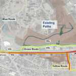
The Pare team outlined four possible routes, two on the north side of Pleasant Street and two on the south side, each with a few variants. (See slides 35 to 37 of the May 18 presentation for details).
Route alternatives prepared by the Pare Corporation. The Red Route is the recommended route.
The routes on the north side have two main variants:
- Crossing Pleasant Street at the Clark Street Bridge and then either re-crossing Pleasant near the entrance to Star Market and traversing the south side of the Star Market parking lot to Trapelo Road, or
- Climbing Belmont Hill to reach Mill Street then crossing Mill Street and Trapelo Road to reach Beaver Brook Reservation and circling back down to Waverley Square.
These two routes not only require crossing more busy roads than the southern route options, but are also inaccessible to Belmont residents living on the south side of the tracks in Precincts 3, 4, and 5, except at Waverley Square and Clark Street. Indeed, they mostly cross the town’s (unpopulated) conservation land.
The routes on the south side ranked higher on the Pare scoring matrix because they are accessible to a large number of residents, they allow a path connection to Town Field and the Senior Center, they avoid troublesome Pleasant Street crossings, and they provide a more direct route between Belmont Center and Waverley Square. It is important to keep in mind that the likely construction funding source, the TIP, is purposed for transportation projects, so short connections to potential path users and path directness are important funding considerations.
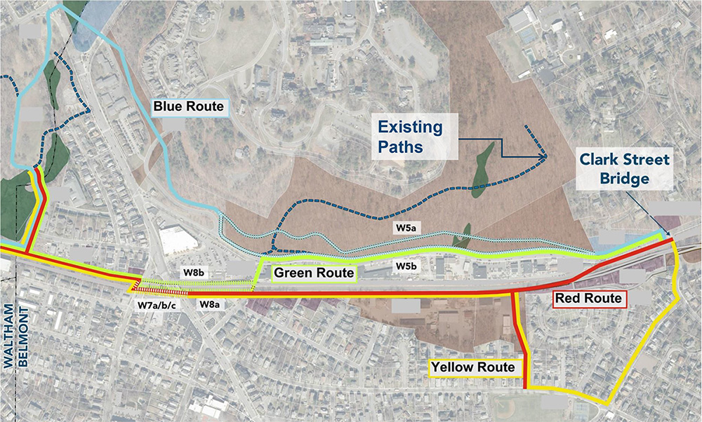
The specific route recommended by the Pare/Toole team and subsequently endorsed by CPPC starts at the Clark Street Bridge and proceeds west as follows:
- Initially along the north side of the Fitchburg Line tracks, on MBTA owned land between the tracks and Pleasant Street, then
- Crossing to the south side of the tracks just before reaching the first commercial building on south Pleasant Street (750 Pleasant Street) via a new pedestrian/bicycle bridge over the Fitchburg Line, terminating in the northeast corner of the Belmont Village parking lot, then
- Proceeding west along the back edge of the Belmont Village parking lot along a descending ramp, reaching ground just before the Town Yard,
- With a spur extending south from the path along the eastern border of the Town Yard and Midland Street to reach Town Field and the Senior Center, with the main route continuing
- Along the north edge of the Town Yard, partially on MBTA land
- Past the ends of A and White streets (both providing entry/exit points), along the edge of the new mixed use development at 495-505 Trapelo Road to the Trapelo Road bridge,
- Across Trapelo Road at a still-to-be-determined crossing point (but without introducing a new traffic signal)
- Through Waverley Station via a still-to-be-determined route, with options including the south side, the north side or a new platform constructed over the tracks and boarding area (a “box-over”) covered by a small landscaped park, then
- Across Lexington Street and
- Continuing toward Waltham on the north side of the Fitchburg Line tracks, until reaching the Division of Conservation and Recreation’s (DCR’s) Beaver Brook South Reservation, where the path will connect with the existing trail network, and eventually (when complete), the Waltham segment of the MCRT.
The recommended Phase 2 Route. Illustration by Vincent Stanton, Jr.
During the Q&A session that followed the May 18 presentation, several residents asked for better maps illustrating the route options. The design team showed a few photographs captured by a drone flown over the area and subsequently annotated with possible path locations. Those images will likely appear on the project website in the coming weeks.
Once the Select Board weighs in on the final route, the design effort will start with the 25% design stage, which will be reviewed by MassDOT and the MBTA. MassDOT will hold a public hearing after accepting the 25% design and possibly after the 75% design is complete.
The public engagement process will be ongoing. Residents can submit comments and subscribe to updates via the project website. The design stage is expected to last for almost two years, culminating in all relevant regulatory permits and executable construction documents. Once TIP funding is secured—probably after 25% design is complete—path construction will be managed by MassDOT, not Belmont.
Vincent Stanton, Jr. is a Belmont Citizens Forum board member and a member of the Belmont Community Path Project Committee. The opinions in this article reflect his views, not necessarily those of the BCF or CPPC.

Sorry, the comment form is closed at this time.