Route, Design, and Funding to be Determined in the Next Six Months
By Vincent Stanton, Jr.
The design of the Belmont Community Path, last reviewed in the May/June2018 and July/August 2018 issues of the BCF Newsletter, has moved closer to reality in the last six months with leadership from the Belmont selectmen and financial support from Town Meeting. However, further important decisions loom in the next six months. The selectmen will make a final decision about the route in eastern Belmont (the focus of this article); Annual Town Meeting will vote on design funding for the path segment from Brighton Street to Clark Street; and the newly formed Community Path Project Committee (CPPC) will hire an engineering consultant to begin 25 percent design.
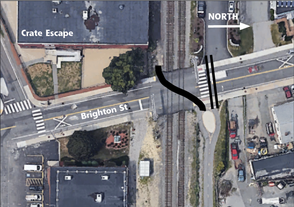
Figure 1. This illustration shows two alternative routes for the Brighton Street crossing. It reproduces a map the MBTA sent to Belmont Town Administrator Patrice Garvin that expressed “dire concerns” about a path crossing the Fitchburg Line tracks at Brighton Street (represented by the curved line across the tracks). This southern route was dismissed as unsafe, and the MBTA further noted that “this accident scenario would be avoided by keeping the bike path on the north side of the track.” The double black line shows the northern route. (Google Earth photo)
The decisions that lie ahead are shaped by these recent developments:
- On July 12, the Belmont Community Path was accepted as an official Massachusetts Department of Transportation (MassDOT) project (not to be confused with a funding decision by the Boston Metropolitan Planning Organization, which will only come after the town has submitted a design). The town’s application covers the eastern half of Belmont, from the Clark Street bridge to Brighton Street, designated “segment 1” and prioritized because: (i) design of the path needs to be coordinated with design of the new grade 7–12 high school campus, and (ii) there is already a connecting path from Brighton Street to Alewife Station. (A future application will address “segment 2,” in the western half of Belmont, from Clark Street to the Waltham border.) Segment 1 has two components: 1A, covering a tunnel beneath the Fitchburg Line tracks at Alexander Avenue and extending across the high school campus to Concord Avenue, and 1B, covering Brighton Street to the Clark Street bridge along the tracks. The details of the 1B route were left open. MassDOT acceptance of the Belmont project starts a two-year clock on initiation of 25 percent design; otherwise Belmont will lose its place in the project funding queue.
-
On October 5, the Community Path Implementation Advisory Committee (CPIAC), at its final meeting, voted 3–2 in favor of the route recommended in the Pare Corporation–K3 Landscape Architecture feasibility study. That route traverses the north side of the railroad tracks from Belmont Center to Alexander Avenue, crosses to the south side via an underpass, then continues on the south side of the tracks past the Purecoat North property to Brighton Street. CPIAC members disagreed about how to act on new developments since the Pare report (discussed below).
-
On November 13, Town Meeting appropriated $400,000 from the Community Preservation Act (CPA) fund for design of segment 1A. Town Meeting was informed that the selectmen intend to sponsor another article at spring Town Meeting to appropriate another $1 million in CPA funds for design of segment 1B. Town Meeting also approved borrowing authority of $295 million for construction of the new 7–12 school.
-
On November 16, MBTA Assistant General Manager for Commuter Rail Operations John D. Ray sent a letter to the Belmont town administrator expressing strong support for the Alexander Avenue underpass but reiterating MBTA’s previously communicated “dire concerns” about a path crossing the Fitchburg Line at Brighton Street (i.e., about the top recommendation of the Pare feasibility study). (See Figure 1.)
-
On November 19, the selectmen, after 90 minutes of public input, indicated that they will make a final decision about the route for 1B in the next few months.
-
On November 28, the new CPPC held its first meeting and in December elected Russ Leino chair and Bonnie Friedman vice chair.
The Pare feasibility study identified 14 route segments between Belmont Center and Brighton Street (three options from the center to the high school football field, three options for an underpass, five options from the football field to Brighton Street, and three options for crossing Brighton Street). These segments could be connected in dozens of configurations providing a through connection. To simplify route prioritization, Pare ranked each of the 14 route segments separately, using 23 criteria (established with extensive public input) relating to user experience, environmental and cultural impacts, design attributes, transportation, and cost.
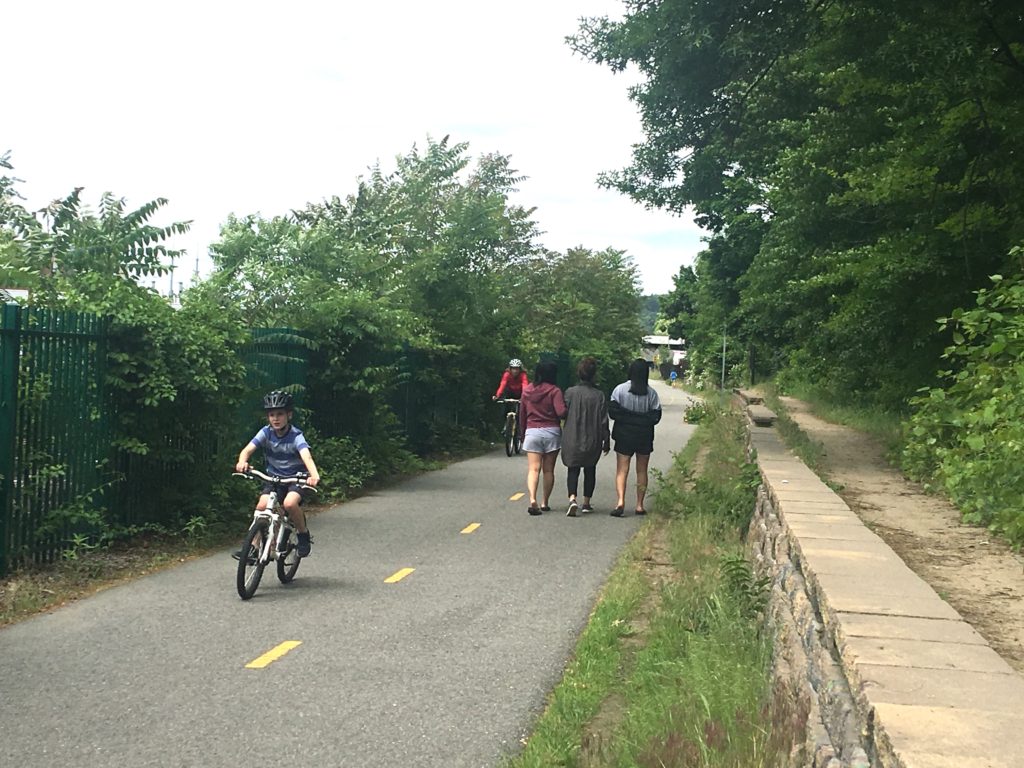
Pedestrians and cyclists on the Fitchburg Cutoff path near Brighton Street. (Sara McCabe photo)
The northern route from Alexander Avenue to Brighton Street (segment E3a) scored 4.60 (out of 6.0) while the southern route (segment E3b) scored 4.71. However, a review of the Pare route ranking matrix makes it apparent that three key assumptions of the Pare study have changed since mid-2017 when Pare completed its work:
1. Pare assumed that funding for an underpass at Alexander Avenue could only be assured by routing the path through the underpass.
In the concluding section of the feasibility study, under “Recommended Route,” Pare wrote (on page 49) that if an all-northern route was selected, “The Alexander Avenue underpass may not qualify for path funding.”
New information: MassDOT has formally accepted Belmont’s proposal to separate segment 1A (underpass and path to Concord Avenue) from segment 1B (Brighton Street to Clark Street bridge). Since the underpass does not have to be part of the main east-west route to qualify for funding, Pare’s scoring matrix should be adjusted in the subcategory “Qualify for Funding.”
2. Pare believed that the MBTA would accept an at-grade crossing at Brighton Street.
The feasibility study, in discussing an at-grade crossing of the Fitchburg Line at Brighton Street, notes (on page 38) that it will be necessary to “…provide the safest at-grade crossing possible for the path,” and indeed, two bridges over Brighton Street were evaluated (E4b, E4c) to address this concern. However, in the scoring matrix used to rank path alternatives (see Figure 2), in the “Rail conflicts/proximity” subcategory, Pare ranks the northern and southern routes equally (4 points each), despite the fact that the southern route requires crossing the Fitchburg Line to reach the Fitchburg Cutoff path, while the northern route does not.
New information: As noted before, the MBTA’s head of commuter rail operations, John D. Ray, has recently expressed strong opposition to a path crossing the Fitchburg Line. His views are in line with MassDOT input to CPIAC at a meeting in June 2018, and with MassDOT views expressed to town officials and State Senator Will Brownsberger in several meetings and phone calls over the summer (summarized in a blog post on Brownsberger’s website, willbrownsberger.com). MassDOT officials contacted by Pare did not include senior railroad operations personnel, accounting for Pare not rating the Fitchburg Line crossing at Brighton Street a “fatal flaw.”
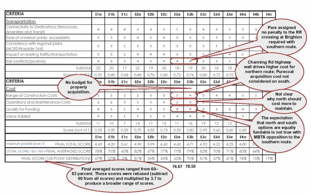
Figure 2. The author annotated the Pare study route scoring matrix (eastern segment) to illustrate just a few of the criteria that have had significant changes since Pare’s original rankings of the southern (E3b) and northern (E3a) routes from Belmont Center to Brighton Street. For the complete annotated matrix, please go to belmontcitizensforum.org.
3. Pare assumed that path money would not be needed to acquire the Purecoat site or an acceptable easement.
The southern route recommended in the Pare feasibility study runs along the south side of the Fitchburg Line tracks east of Alexander Avenue, behind the present high school and tennis courts. From there, it traverses land owned by Purecoat North and would require demolishing the northern wall of the Crate Escape building to comply with MassDOT design requirements (23 feet minimum from the rail). The feasibility study hypothesized that the Purecoat site might be acquired by Belmont for the new 7–12 school, but noted (on page 49) that it was uncertain, and a contingent route was therefore necessary:
“Due to the ongoing nature of the Belmont High School feasibility study being conducted with the MSBA, which may or may not entail future purchase of all or part of the Purecoat North/Crate Escape parcel by the Town for school expansion purposes, there is no assurance that this site will be able to accommodate the path as recommended. Should the high school property be unusable between Alexander Avenue and Brighton Street, the route is recommended to defer to Alternative E3a in this stretch, utilizing the Belmont Citizens Forum property on the north side of the rail between Alexander Avenue and Brighton Street. This may alter the funding capability of the Alexander Avenue underpass, as described in the subsequent Funding Section of this report.”
Crucially, the feasibility study did not assign any cost for property acquisition, wall demolition, or reconstruction associated with the southern route (E3b). This is important because the southern route scored higher than the northern route (E3a) only because it ranked significantly less costly (16 vs. 11 points) in the scoring matrix. In the other four main categories, the northern route scored slightly higher.
Note that northern route costs are high (from $4.24 to $5.43 million) mainly because of the cost of a 10-to-15-foot-tall highway-type wall (preferred by many Channing Road residents if the northern route is selected). Pare assumed (per CPIAC instruction) the highest cost option for each path segment, and along the northern route, the highest cost option is the highway wall.
New information: Now that Town Meeting has voted $295 million for design and construction of a new 7–12 school on the high school campus, it is 100 percent certain that acquisition of the Purecoat site will not be part of that project. The Purecoat property could in theory be acquired by Belmont for the path, but there is no plan or budget to accomplish that. Further, state and federal funding would not be available for that purpose; right-of-way acquisition is the responsibility of the town. Therefore it is no longer defensible to evaluate the southern route option without any budget for the Purecoat site. The asking price for that property was about $8.5M in 2011, when Belmont sought to purchase it as a site for the new electric substation. The cost of an easement plus demolition and reconstruction of the Loading Dock restaurant might be less, but still would likely match or exceed even the most conservative costs associated with the northern option.
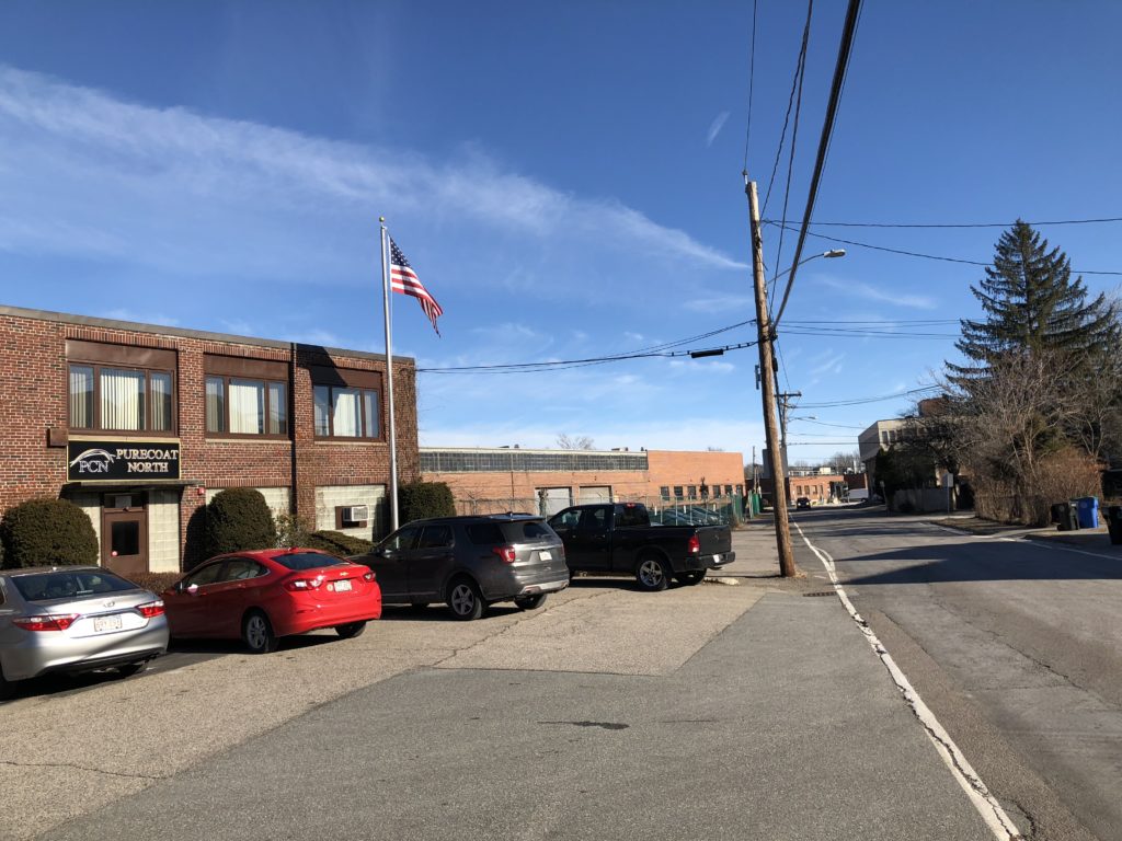
Above, the Purecoat North office building on Hittinger Street looking towards Brighton Street, and below, Crate Escape at the corner of Hittinger and Brighton. A southern route for the path would require complicated and costly easements affecting these two businesses. (Sara McCabe photos)
In summary, the new developments outlined above compel a re-think of the Pare feasibility study recommendations for eastern Belmont. The northern and southern options ranked very closely in the Pare study, but in view of new facts, the northern route is almost certainly less expensive and (by Pare’s scoring matrix) higher ranking.
More important, the vigorous opposition of the MBTA to a crossing at Brighton Street is very likely to compromise Belmont’s chances for obtaining construction funding from the Boston Region Metropolitan Planning Organization (MPO). The 22-member MPO evaluates and votes on applications for Transportation Improvement Program (TIP) funds. Three members are appointed by the secretary of transportation and two members come from the MBTA (one from the advisory board). Most of the other members are planning directors or selectmen from cities and towns inside Route 495 (the area covered by the Boston MPO). Thus the views of the MBTA are definitely heard in the MPO evaluation process, which is highly competitive.
Vincent Stanton, Jr., is a Belmont Citizens Forum board member and also a member of the newly appointed Community Path Project Committee. However, the views expressed in this article and sidebar are entirely his own.
Reviewing Recent Arguments for the Southern Route
At its final meeting, CPIAC split three to two on how to proceed in view of some (but not all) of the recent developments described in the accompanying article. The view of the majority included the following points:
(i) The MBTA’s objections could eventually be circumvented by extending the route on the south side of the Fitchburg Line into Cambridge, and connecting it to an envisioned pedestrian bridge over the Fitchburg Line, starting at 55 Wheeler Street (one block west of Fresh Pond Parkway, behind the Trader Joe’s store). This would provide an alternate route from Belmont to Alewife Station.
(ii) Since the Belmont path is a high-priority segment of the Mass Central Rail Trail, MassDOT and the Boston MPO would bend to Belmont’s wishes.
(iii) The concerns of some Channing Road abutters deserve strong consideration.
CPIAC chair Russ Leino and I voted against a motion to recommend that route along the south side of the tracks in Cambridge for the following reasons:
(i) It would imperil Boston MPO funding for construction of the Belmont Community Path, given the voice of the MBTA in MPO deliberations and the competitive nature of the funding process (far more projects are reviewed than can be funded).
(ii) It is a purely hypothetical route—Cambridge has no plans for such a path; indeed, the concept has never been discussed. And it seems nearly impossible that such a plan could be designed and accepted within 18 months (Belmont’s deadline for initiating 25 percent design of a final route to keep its current place in line).
(iii) Belmont would be delegating to Cambridge the design and funding of a crucial connecting link, without which the Belmont southern route would not address the MBTA’s concerns.
(iv) The route to Alewife via Trader Joe’s, through an industrial area of Cambridge, would be inferior from aesthetic, transportation, and accessibility perspectives to the existing Fitchburg Cutoff Path, which passes through a landscaped park. From a transportation perspective, the southern route to Alewife would be about 40 percent longer than the existing northern path, and would probably be partly along roads. From an accessibility perspective, the route would have to clear the Fitchburg Line by 22.5 feet, requiring a greater-than-45-foot vertical rise and descent.
(v) It may be difficult to obtain MPO funding for a duplicative southern route along the Fitchburg Line in Cambridge when a direct path from Brighton Street to Alewife already exists.
View of 55 Wheeler Street, behind the Fresh Pond Trader Joe’s store, where advocates for a south side route claim that a new pedestrian connection to Alewife Station could be built. (Sara McCabe photo)
At the November 19 Board of Selectmen meeting, Brian Burke, a CPIAC member, repeated arguments he had made at the CPIAC meeting on October 5, including many demonstrably false claims about the status of land holdings and project planning. Here is an example (bracketed text inserted for clarity; see a video of the entire meeting at the Belmont Media Center website, belmontmedia.org):
“We [Belmont] own a right-of-way [along the south side of the tracks] from Brighton Street all the way to the other end [the Cambridge electric substation] because we bought it from the City of Cambridge for the electric power lines,” Burke said, implying that Belmont had control of the land for a southern path through Cambridge. He further stated that he had spoken with two Cambridge planning officials, including director of community planning Melissa Peters and that, “Both of them were surprised that we [Belmont] didn’t already realize that we had a right-of-way. We own a right-of-way from Brighton Street all the way to the end [Alewife], because we bought it from the City of Cambridge.”
Town planner Jeffrey Wheeler corrected Burke, pointing out that Belmont Light had only secured a limited easement to a 16-foot-wide corridor for construction and maintenance of underground cables. (The easement, recorded in Middlesex South Registry of Deeds, book 60825, page 425, was obtained from the MBTA, which is the actual owner of the land, and specifies that the easement is: “… for the purpose of laying, constructing, inspecting, reconstructing, operating, maintaining, repairing, replacing, rebuilding and or upgrading said Grantee’s Improvements… such upgrading to be limited to adding additional lines and/or cables within existing ductbanks or conduits….”) The Belmont Light easement was not secured from Cambridge—which never owned that land—and would not permit construction of a path, which raises questions about the accuracy of Burke’s recollections of his conversations with Cambridge planning officials.
View of 55 Wheeler Street, behind the Fresh Pond Trader Joe’s store, where advocates for a south side route claim that a new pedestrian connection to Alewife Station could be built.
When told by Wheeler that the easement was not suitable for a path, Burke responded that, “The entire western bike path, which is almost complete, is entirely on the electric light company property. They paved it and they built it. They will pave it for you [Belmont].”
This statement is also untrue. The MBTA owns the former Massachusetts Central Railroad right-of-way (acquired after the Boston and Maine Railroad filed for bankruptcy in 1970). In 2010, the MBTA granted a 99-year easement to the Massachusetts Division of Conservation and Recreation (DCR) for construction of a rail-trail along a 19-foot-wide corridor between Beaver Street in Waltham westward to the town of Berlin. DCR obtained a waiver from full environmental review and has been working with towns along the right-of-way to advance the path.
Eversource holds a power transmission easement from the MBTA along sections of the Mass Central Rail Trail (MCRT) corridor, but not in Belmont. Eversource will pay for grading and a gravel subsurface for four miles of the MCRT in Weston and Wayland (in order to access its transmission line), while DCR will pay $1.5 million to pave that section.
The misrepresentation of this arrangement by Burke, along with other misstatements—for example, suggesting that contamination of railroad land north of the tracks is a big problem while similar contamination on the south (perhaps worse because of Purecoat North waste) is negligible—tend to undermine his credibility.
—Vincent Stanton, Jr.
REFERENCES
Author Vincent Stanton, Jr.’s annotated scoring matrix from the Pare feasibility study
https://www.belmontcitizensforum.org/wp-content/uploads/2019/01/Pare-ranking-matrix-VS-annotated.pdf
Author Vincent Stanton, Jr.’s annotated cost ranges from the Pare feasibility study
https://www.belmontcitizensforum.org/wp-content/uploads/2019/01/Pare_cost_ranges_VS-annotated.pdf
Belmont maps
Belmont Community Path map from Pare Corp. feasibility study
https://www.belmont-ma.gov/sites/belmontma/files/uploads/bcp_-_phase_1.pdf
Belmont GIS map
https://www.mapsonline.net/belmontma/index.html
Pare Corp. – K3 Landscape Architecture Belmont Community Path feasibility study documents
Feasibility study
Route scoring matrix
https://www.belmont-ma.gov/sites/belmontma/files/u151/matrix-long-042617.pdf
Budget ranges for each route segment
https://www.belmont-ma.gov/sites/belmontma/files/u151/alternative_cost_range_042617.pdf
Belmont Community Path Project Documents submitted to MassDOT/Boston MPO
Project Need Form (PNF)
https://www.belmont-ma.gov/sites/belmontma/files/uploads/projectneedform_final.pdf
Project Initiation Form (PIF)
https://www.belmont-ma.gov/sites/belmontma/files/uploads/projectinitiationform_final.pdf
Pare feasibility study budget annotated to highlight costs for segments 1A and 1B
https://www.belmont-ma.gov/sites/belmontma/files/uploads/alternative_cost_range_pif.pdf
MassDOT input on crossing the Fitchburg Line at Brighton Street
Letter from MBTA Assistant GM for Commuter Rail and Ferry Operations John D. Ray
Sen. William Brownsberger blog post about MBTA input
https://willbrownsberger.com/moving-forward-with-the-belmont-community-path/
Boston Metropolitan Planning Organization
Members
http://www.ctps.org/mpo_membership
MassDOT policies
Chapter 11 of the 2006 MassDOT “Project Development & Design Guide” provides guidance on path design, including rail-with-trail design.
MassDOT’s right-of-way acquisition process and policies
https://www.massdot.state.ma.us/Portals/0/docs/infoCenter/realEstate_assetDev/rowmanual.pdf
Belmont selectmen’s meetings at which community path matters were discussed
November 19, 2018
https://www.belmontmedia.org/watch/board-selectmen-111918
Eversource role in MCRT funding
Recent path articles in the BCF Newsletter
May/June 2018: Belmont Community Path Update, Part One
https://www.belmontcitizensforum.org/2018/05/15/belmont-community-path-update-part-one/
July/August 2018: Belmont Community Path Update, Part Two
https://www.belmontcitizensforum.org/2018/07/17/belmont-community-path-update-part-two/

Sorry, the comment form is closed at this time.