Feasibility Study Plan Offers Health and Safety Benefits
By Vincent Stanton, Jr.
Design and construction of a bicycle and pedestrian path through Belmont have been on the town’s agenda intermittently since 1993, when the selectmen first appointed a temporary committee to study possible routes. The motivation for a path has always been to provide recreational opportunities for Belmont residents and to connect Belmont to surrounding towns and to transit, particularly Alewife Station. Waltham, Cambridge, Somerville, Weston, and Wayland have all made significant progress toward path construction over the last five years.
In the May/June issue of the Belmont Citizens Forum Newsletter, I highlighted three important aspects of the community path plan recommended by Pare Corp. and K3 Landscape Architecture (the Pare team):
- It brings Belmont commuter rail stations (almost) into compliance with the Americans with Disabilities Act, which could save Waverley Square Station from closing when its ADA waiver expires in 2026.
- It provides new, off-road pedestrian and bicycle connections to bus and rail transit for Belmont residents, which should increase use of mass transit and decrease traffic congestion.
- It creates a new, ¾-acre public space in Waverley Square by boxing over the train platform with a park.
This issue picks up where we left off, with three more benefits (#4, 5, 6) of the proposed path.
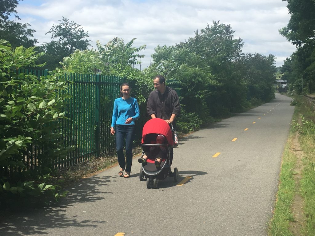
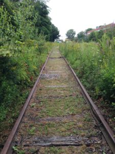
On any given weekend during warm months, the Belmont section of the Fitchburg Cutoff path (the first 603 feet) is in heavy use by walkers, runners, and families with strollers and children on bikes. (Sara McCabe photo)
4. New off-road routes to school
The fortunate coincidence of designing a community path and a new middle/high school campus, which the community path will traverse, should allow the school transportation elements of a path to be fully exploited. The recent decision by the Belmont High School Building Committee to include middle school grades 7–8 will make the new school eligible for Safe Routes to School funding. (Scroll down to see “Safe Routes to Schools” sidebar below.) Researchers at Columbia University have documented 20 to 40 percent reductions in pedestrian and cyclist injuries after implementation of Safe Routes to School infrastructure.1
Altogether, about 30 percent of Belmont’s residents, and by extension its middle and high school students (about 680 students by 2025-26, a realistic date for path completion), live close enough to the proposed path to either shorten their journey to the proposed new school, or reduce the number of major road crossings, or both.
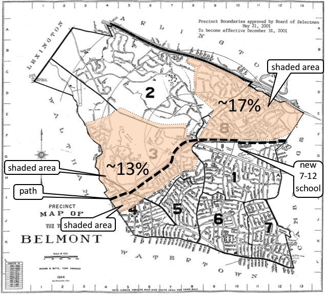
Figure 1: Belmont students whose commute would be shorter and/or safer on the path.
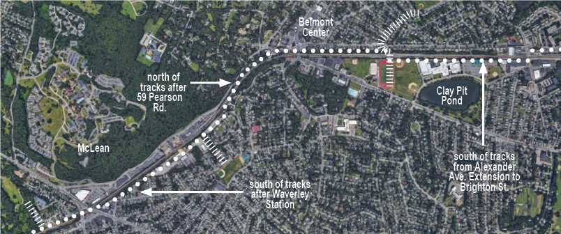
The two shaded areas mark the estimated school population that could reach the proposed new grade 7–12 school faster and more safely via the path (heavy dashed line), for at least part of their journey, than on existing roads and sidewalks. (Town of Belmont map)
For example, a student living on A Street currently walks or bikes along Waverley, Thomas, and Clark Streets to Royal Road, then jaywalks across Common Street in front of the Lions Club and crosses Concord Avenue in front of the post office to reach the high school. By using the path, this student could avoid crossing 15 streets and reduce his or her commuting distance from about 8,020 feet to about 6,890 feet (estimated using Google Earth).
While the current number of students who walk or bike to school is not known, it may not reflect the future number. Recent research has shown that paths perceived as safe attract new users, who may have been unwilling to use previous on-street routes.2
Those who perceive on-street biking as unsafe (an off-road path was the top priority of 90 percent of Belmont residents polled by the Community Path Advisory Committee) are on to something: walking and biking is far more dangerous in the United States than in European countries with higher use of those modes of transport.3 In 1970 Denmark and the Netherlands had injury and fatality rates comparable to those in the U.S. today. Over the ensuing five decades, a gradual extension and improvement in design of their walking and bicycle infrastructure has brought down their injury and fatality rates substantially. Fatalities are less than 20 percent of U.S. rates, and injury rates less than 10 percent of U.S. rates.2
Improved safety is not limited to avoidance of roads and busy intersections. For decades students in the Winn Brook neighborhood have been crossing the Fitchburg Line to commute to Belmont High School and to a lesser extent Chenery Middle School. (See “Alexander Avenue Underpass” sidebar on page 4). Several students have died in train collisions, in some cases as suicides. The proposed Alexander Avenue Extension underpass would provide a safe, convenient route under the tracks, while a high fence or wall would be built parallel to the tracks, preventing casual track crossings.
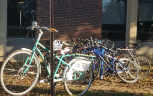
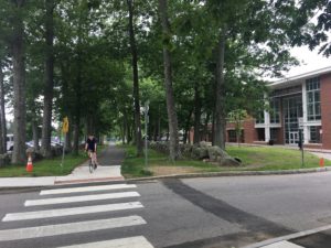
“Bike racks all over campus are full on September mornings,” noted a traffic study by the Belmont High School Building Committee’s design consultant Perkins+Will Global. (Perkins+Will photo)
5. Recreation and health benefits
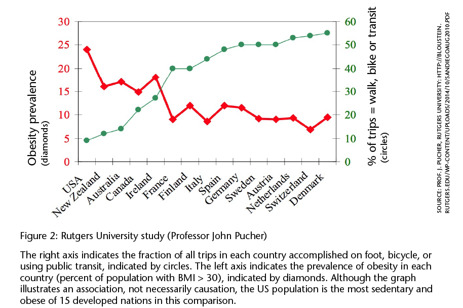
Researchers at Rutgers University have noted an inverse relationship between the fraction of a developed country’s population that regularly walks, bikes, or uses public transit (which requires some walking or biking) and the fraction that is obese (see Figure 2 below).
A path would create attractive new opportunities for safe and efficient walking or cycling to frequently visited Belmont destinations. For example, for Winn Brook residents there are “lines of desire” to a variety of Concord Avenue destinations, including recreational facilities
at the high school, the Underwood pool, the library, Powers Music School, the post office, and the 74 bus line.
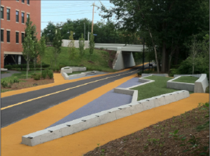
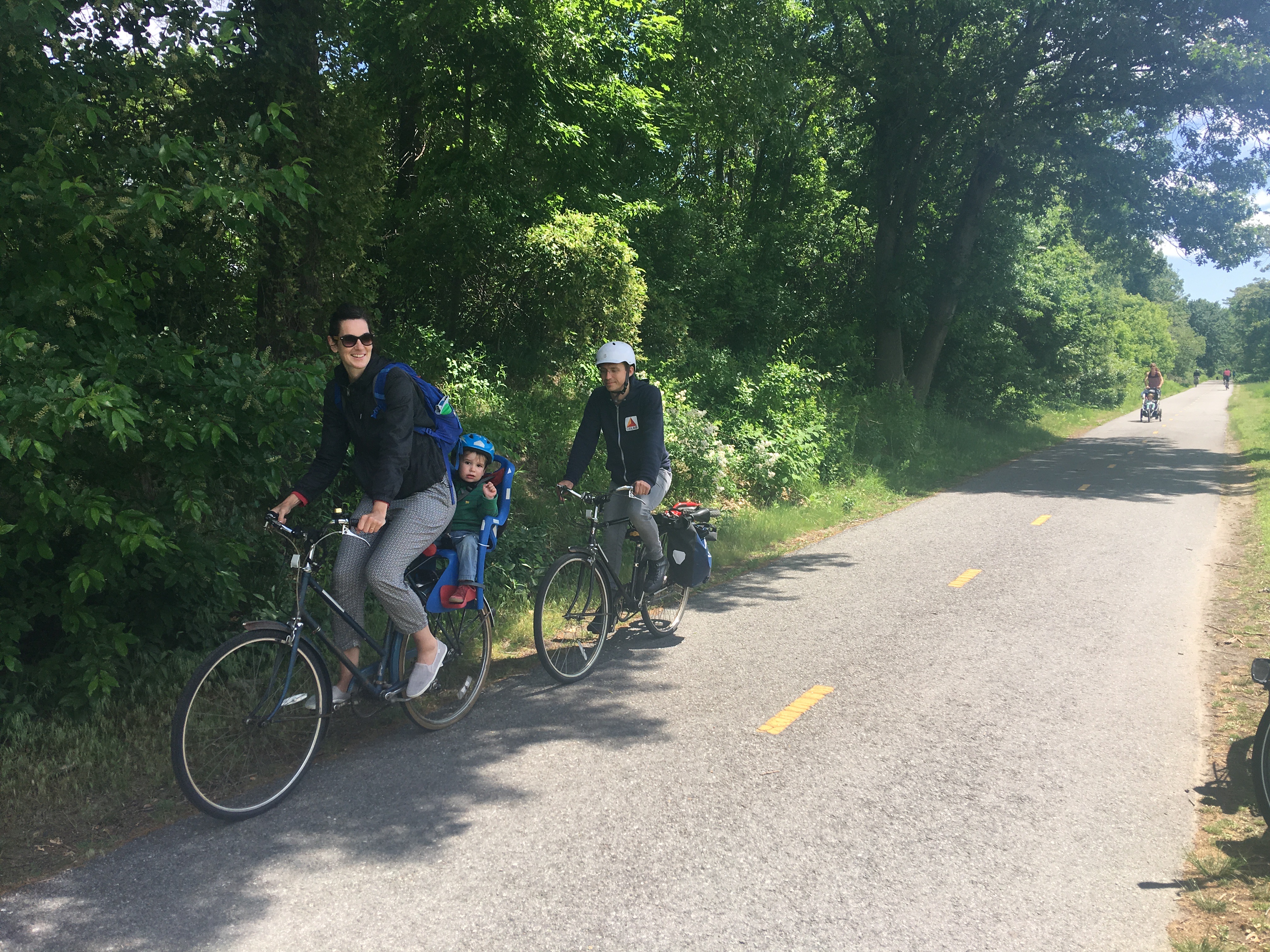
The community path extension in Somerville was designed with recreational enhancements such as the rest area seen here (near the Lowell Street bridge), as well as benches and exercise stations. In these areas, the asphalt path is bordered by a flexible, spongy surface. (Vincent Stanton, Jr. photo)
For some residents living south of the Fitchburg Line and west of Belmont Center, including residents of Belmont Village (the town-owned housing development east of the Town Yard), the path would provide the same improved access to the cluster of recreational facilities around the high school, while also affording new, shorter routes to businesses and transit options in Belmont Center and Waverley Square.
All residents living near the path would benefit from a shorter route to Alewife Station—indeed, the bicycle commuting time would probably be less than half the automotive commuting time at rush hour. Shorter, safer routes to the 73 and 74/75 bus lines and to Waverley and Belmont Center commuter rail stations would also be provided by the path.
The purely recreational aspects of a Belmont path—jogging, skating, bicycling —will depend on its design. The purpose of the Pare study was to evaluate the feasibility of different routes, not to design the path. However, a sense of what is possible can be gleaned from the recently completed Somerville community path extension, which can fairly be described as a linear park, with exercise stations and benches along the path.
6. New community connections
In addition to trailheads (places to enter or exit the path), the Pare study proposes four future spurs. One spur would connect to Beaver Brook Reservation, a second to Town Field and the Beech Street Center, and two others to destinations north and south of the proposed Alexander Avenue underpass. These spurs are not in the Pare budget, though they are vital to a full realization of the Belmont path.
This map of the proposed route with spurs appeared in “Part One” of this article in the May/June issue of the BCF Newsletter. (Google Maps image)
The first spur to Beaver Brook Reservation would make the park more accessible to many Belmont residents, including children. Currently the main access to the reservation is by car from a few parking spots along Trapelo Road, and from a parking lot off of Waverley Oaks Road in Waltham.
The second spur would extend south along the eastern edge of the Town Yard, continue along the side of Midland (a dead-end street) to Waverley Street, where a new crosswalk would connect to Town Field and the Beech Street Center. This spur would allow families who participate in organized soccer and baseball games at Town Field to reach the field via foot or bike.
Safer, easier access to the Beech Street Center could also be useful to the approximately one-quarter of Belmont residents age 60 and above, and the path would offer them a new location for walking and other low-impact exercise. The 2016 report, Envisioning an Age-Friendly Belmont, prepared by researchers at the University of Massachusetts Boston for the Belmont Council on Aging, identified eight domains of community life that collectively constitute an age-friendly framework, and three of those (transportation, outdoor spaces, and social participation) intersect with use of the path.
The third and fourth spurs would connect the two sides of town via the proposed Alexander Avenue underpass: Channing Road and the Winn Brook School and playground north of the tracks, with Concord Avenue and the high school campus south of the tracks. The northern spur would improve access to the path and destinations south of the tracks for many Winn Brook area residents, while improving access to Joey’s Park and the playing fields for residents living south of Concord Avenue. The southern spur, which would likely cross the high school campus just east of the football field, would provide access to the path for the nearly half of Belmont residents who live south of Concord Avenue and east of Belmont Center, as well as connections to Concord Avenue amenities for Winn Brook residents.
Multiple trailheads at Belmont Center and Waverley Square will connect path users to two of the main business districts in Belmont. Data from a variety of sources suggest that the path should benefit Belmont businesses (reviewed in the Community Path Advisory Committee final report, pages 41–42). For example, a 2012 study by Portland State University researchers found that patrons of restaurants, bars, and convenience stores who arrived on foot or bike spent more per month (per person) than patrons arriving by car because they visited more frequently.4
Ultimately a more extensive network of spurs will make the path useful to more Belmont residents. As a precedent, spurs off the Minuteman Bikeway are still being constructed in Arlington, Lexington, and Bedford 25 years after the trunk route opened. In Belmont, Lone Tree Hill and the Grove Street and Pequosette playgrounds are three examples of resources that could be more easily accessed by residents through spurs from the path. And Kendall Gardens and Royal Belmont are both prime examples of less accessible neighborhoods that could benefit from easy walking or biking connections.
A Belmont family near the end of the Belmont Community Path at Brighton Street, which will ultimately connect to Boston via the Cambridge Linear Path, the Somerville Community Path, and the Green Line Extension path, and to Waltham, Weston, Wayland, Sudbury, Hudson and Berlin via the Mass Central Rail Trail. (Sara McCabe photo)
Progress on funding possibilities
The first part of this article in the May/June issue outlined arguments for MassDOT and MBTA funding assistance for the Belmont path. Through meetings with town, state, and MassDOT officials in June, the project has been re-framed as a three-stage project:
1A. Alexander Avenue Extension underpass with connections to Concord Avenue and the Winn Brook neighborhood
1B. Brighton Street to Clark Street bridge
2. Clark Street bridge to Waltham line
On July 19, the MassDOT Project Review Committee is scheduled to vote on whether to accept segments 1A and 1B of the Belmont path as an official MassDOT project. For the results of that vote and a summary of next steps, please go to belmontcitizensforum.org.
Vincent Stanton, Jr. is a Belmont Citizens Forum board member. He served on the Community Path Advisory Committee (2012–2014) and is now a member of the Community Path Implementation Advisory Committee. However, the views in this article (and sidebars) are entirely his own.
Click here for a September 21, 2018 update from state Senator Will Brownsberger and state Representative David Rogers.
Footnotes
1. DiMaggio C., Frangos, S. and G. Li. National Safe Routes to School program and risk of school-age pedestrian and bicyclist injury. Annals of Epidemiology 2016 Jun; 26 (6): 412-7. https://www.annalsofepidemiology.org/article/S1047-2797(16)30083-7/pdf
2. Hull, A. and C. O’Holleran. Bicycle infrastructure: can good design encourage cycling? Urban, Planning and Transport Research: An Open Access Journal, 2014 Vol. 2, No. 1, 369–406. https://www.tandfonline.com/doi/pdf/10.1080/21650020.2014.955210?needAccess=true
3. Pucher, J. and R. Buehler. Making Cycling Irresistible: Lessons from The Netherlands, Denmark and Germany. Transport Reviews, vol. 28, no. 4, pp. 495–528, July 2008.
4. Clifton, K.J. et al. Business Cycles—Catering to the Bicycling Market. TR News 280, May–June 2012, p. 26-34. http://kellyjclifton.com/Research/EconImpactsofBicycling/TRN_280_CliftonMorrissey&Ritter_pp26-32.pdf
Alexander Avenue Underpass: The Time Has Come
Belmont students have been crossing the Fitchburg Line tracks at least since the current Belmont High School opened in 1971. Indeed, Selectman Mark Paolillo (BHS ’72), who grew up in the Winn Brook neighborhood, admits to using the shortcut as a student.
A safe crossing of the Fitchburg Line at Alexander Avenue Extension has been designated a priority by at least half a dozen Belmont committees since 1971, and by four independent studies conducted by private firms or state agencies since 1997.
In 1983, Town Meeting voted to form the Underpass Study Committee following the 1982 death of a high school student on the Fitchburg line tracks. The committee determined that an estimated $500,000 underpass would be too costly for the town, and state or federal funding was not considered likely. The committee ended up recommending a bicycle-pedestrian path over the tracks. But the MBTA was not consulted on the plan, and nothing came of it.
In 2008, the Capital Projects Overview Committee recommended construction of a tunnel beneath the MBTA railroad tracks. In 2010, the Belmont Planning Board completed its Comprehensive Plan for Belmont, which recommended an underpass at Alexander Avenue as a high-priority action item.
In 2012, the Boston Metropolitan Area Planning Council, a regional planning agency, published the Belmont/Waltham Trail Alignment Study, which strongly recommended an underpass at Alexander Avenue regardless of path location, stating, “A bicycle and pedestrian underpass at Alexander Avenue should be a high priority no matter which trail alignment option is chosen. Fences do not deter the desire to avoid a one-mile detour to provide direct and safe access between both sides of the tracks.” In 2015, the Belmont Community Path Advisory Committee also endorsed an underpass at the Alexander Avenue Extension.
Waltham Trail Update
By John Dieckmann
Design of the Waltham segment of the Mass Central Rail Trail (MCRT), known in Waltham as the Wayside Trail, is moving ahead rapidly. In early June, the design engineers (Pare Corporation) presented the 25% design of the central section, which runs just under three miles between Beaver Street and 1265 Main Street. The central section design includes six road crossings with traffic controls and two bridges. The 75% design should be done by early fall, with 100% design by the end of 2018.
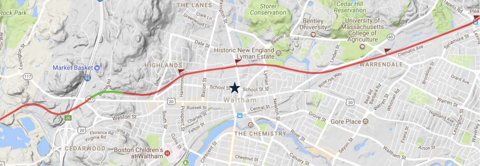
The planned route of the Waltham segment of the Mass Central Rail Trail. (Tom Kelleher and Google maps)
A section of the rail looking east toward Belmont, close to Beaver Street.(Laurel Carpenter photo)
To expedite the work, the city of Waltham is planning a separate contract for removal of rails and ties. Bids for trail construction are expected in early 2019; the goal is to finish the trail by late fall 2020. Construction funding for the Waltham segment of the Wayside Trail has not yet been confirmed but may include partnerships between the city (including CPA funds) and state funds.
Design will continue at a less accelerated pace on the two remaining Waltham segments of the MCRT. East of Beaver Street, the original Central Massachusetts Railroad right-of-way has been compromised, so the trail must pass through MBTA land, private property, and the Beaver Brook reservation to reach the Belmont town line. Details and permitting are yet to be worked out. West of 1265 Main Street, at the 128/I-95 crossing, the MBTA right-of-way exists, but Pare cannot complete the trail design without knowing how the state plans to modify the I-95/Rt 128 interchange. This interchange is a separate design contract in conjunction with MassDOT. Once the design of the central section is complete, attention will turn to the east and west sections.
Information about the Waltham section of the Wayside Trail can be found on the city’s planning department pages at city.waltham.ma.us/planning-department/pages/healthy-transportation
John Dieckmann is a member of the Belmont Citizens Forum board and an avid cyclist.
Safe Routes to Schools: What are Other Nearby Communities Doing?
Safe Routes to School (SRTS) is a federally funded program administered by MassDOT. The goals of the program are concisely summarized on the MassDOT SRTS webpage:
“Safe Routes to School works with schools, communities, students, and families to increase biking and walking among elementary and middle school students in the Commonwealth. We promote a collaborative, community-focused approach that fosters mutual partnerships between advocacy groups, law enforcement, education leaders, and public health departments that all work together to promote safer routes for elementary and middle school students to get to school.”
Many Greater Boston towns, including Bedford, Arlington, Billerica, Somerville, and Watertown, have received substantial SRTS grants for pedestrian and bicycle infrastructure. Here are a few examples.
Because the middle school shares a campus with Bedford High School, the Bedford public library, and town hall, the path connects all of these destinations, as well as with Great Road on the other side. (Sara McCabe photos)
Bedford
SRTS paid for 100 percent of design and construction on the $1M path connecting the John Glenn Middle School to the Minuteman Bikeway Extension via Railroad Avenue, completed last year.
Arlington
In 1998, Arlington was one of the first two towns in the country to start a Safe Routes to School program, funded initially by a $50,000 pilot grant. Subsequently, in 2010 the Dallin Elementary School received a $540,560 SRTS grant for improved pedestrian access. The Minuteman Bikeway, paid for by the Boston Metropolitan Planning Organization (MPO), is used by a subset of elementary, middle, and high school students to commute; four Arlington schools are within 1,500 feet (roughly a five-minute walk) of the bikeway.
Billerica
In 2013, Billerica Town Meeting appropriated $200,000 for 25% design of the Yankee Doodle Bike Path, which will connect Billerica Memorial High School to the existing Narrow Gauge Rail Trail, which connects (via Bedford) to the Minuteman Bikeway. Town Meeting appropriated another $450,000 for 75% design in 2017. In February 2018, Billerica submitted 25% design documents to MassDOT for approval.
Northern Strand Community Trail
Also known as the Bike to the Sea Path (for its route from Everett to Nahant), this partly constructed community path runs along live and abandoned rail lines while connecting to the campuses of eight schools in six towns, as well as nine playgrounds and parks. While path construction is being funded via the regional Transportation Improvement Plan (TIP) through the federal-state MPO, connections from the path to school entrances have been funded by SRTS grants.
Stoneham, Winchester, and Woburn
The Tri-Community Greenway connects schools, parks, business centers, commuter rail stations, and bus lines in Winchester, Stoneham, and Woburn. Construction of the path, expected to be completed in 2018, is funded by MassDOT through the TIP. The Greenway passes along the campus of the Stoneham Central Middle School in Stoneham, recipient of a $479,910 SRTS grant in 2010, and within half a block of the Goodyear Elementary School. In Winchester, the path connects students to the high school, middle school, and four of the town’s five elementary schools.
Watertown
Watertown was awarded a $903,500 SRTS grant in 2017 for improved pedestrian routes to Hosmer Elementary School, including realignment of a street, new sidewalks, improved crosswalks with bumpouts, and improved signage.
Weston and Wayland
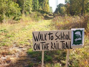
Eversource, the electric utility company, is cooperating with the Massachusetts Department of Conservation and Recreation (DCR) to construct a path along the former Massachusetts Central Railroad right of way in Weston and Wayland by the end of this year. This sign was erected by Friends of the Wayland Trail. (Larry Kiernan photo)
Notable Belmont Path Proponents
While Belmont is still waiting for its community path, several residents have played important roles in advocating for improved bicycle and pedestrian facilities, regulations, and funding.
The first regional mixed-use path of note, an 11-mile circuit of the Charles River basin from the Eliot bridge to the Massachusetts Avenue bridge, was championed from the 1940s through its opening in 1960 by longtime Belmont resident Dr. Paul Dudley White (Marsh Street), after whom it is now named. Dr. White, a nationally prominent cardiologist at Massachusetts General Hospital (MGH), was an early proponent of what is now called preventive medicine. When President Dwight Eisenhower suffered a heart attack in 1955, Dr. White was asked to help care for the President during his recovery and famously recommended bicycle riding to prevent a recurrence.
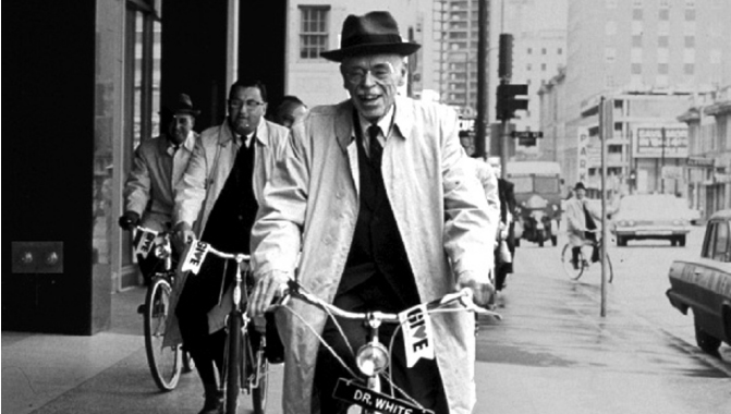
In 1957 Dr. White cofounded the Committee for Safe Bicycling to encourage bicycle riding as a healthy form of exercise and to lobby for bicycle paths during a period when few assigned much value to such facilities. A 1973 Belmont Citizen obituary noted that White was still bicycling in his 80s. (Massachusetts General Hospital, Archives and Special Collections photo)
Former Belmont selectman and state Representative Anne Paulsen (School Street) was an effective advocate for pedestrians and bicyclists throughout her 15-year career in the Massachusetts House of Representatives. In 1996 she successfully sponsored legislation that required MassDOT to include accommodations for bicycles and pedestrians in all state-funded street projects. The law was controversial at the time, as it represented a new way of thinking about the mission of MassDOT. The MassDOT highway design manual (see links online) was rewritten to reflect the new approach. In 2004 Paulsen successfully sponsored legislation requiring the RMV (Registry of Motor Vehicles) to improve its bicycle and pedestrian safety training for driver’s license applicants. Paulsen was also instrumental in recognizing the potential of the Fitchburg Cutoff path, then a dirt path, and later securing funds for design and construction of the present path. (See January/February 2014 BCF Newsletter for a profile on Paulsen.)
State Senator Will Brownsberger (Gilbert Road) has continued Paulsen’s legacy as an engine of pedestrian and bicyclist-related legislation. Last year, for example, legislation he sponsored to penalize drivers for venturing into bicycle lanes became law. Brownsberger is also well known locally for his bicycling exploits; in addition to completing several Ironman competitions (which include a 112-mile bicycle race), in 2011 he biked across the country (3,500 miles) in 41 days. Brownsberger also helped get the Fitchburg Cutoff path funded, and worked with Representative Dave Rogers to secure half of the funding for the feasibility study described in this article. Recently Brownsberger has helped move path planning ahead with MassDOT.
Paulsen used to—and Brownsberger still does—commute to the State House by bicycle. There are no accounts of White commuting to MGH on bike.

Sorry, the comment form is closed at this time.