Belmont Community Path Update, Part Two

 Bicycles and bike paths, Bike Paths, July-Aug 2018, Traffic, Transit  Comments Off on Belmont Community Path Update, Part Two
Jul 172018
 
Belmont Community Path Update, Part Two

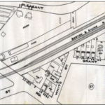
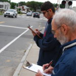
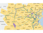
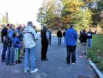
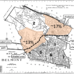
Feasibility Study Plan Offers Health and Safety Benefits By Vincent Stanton, Jr. Design and construction of a bicycle and pedestrian path through Belmont have been on the town’s agenda intermittently since 1993, when the selectmen first appointed a temporary committee to study possible routes. The motivation for a path has always been to provide recreational opportunities for Belmont residents and to connect Belmont to surrounding towns and to transit, particularly Alewife Station. Waltham, Cambridge, Somerville, Weston, and Wayland have all made significant progress toward path construction over the last five years. In the May/June issue of the Belmont Citizens Forum [READ MORE]

Share

Letters to the Editor, July-August 2018

 Bicycles and bike paths, Bike Paths, July-Aug 2018  Comments Off on Letters to the Editor, July-August 2018
Jul 172018
 
Letters to the Editor, July-August 2018

Readers respond to “Part One” of author Vincent Stanton, Jr.’s two-part article on the benefits of the proposed Belmont Community Path from the May-June issue. To the Editor, Nice article about the Belmont section of the Mass Central Rail Trail, and I’m happy to hear of progress on that project. Mini-platforms at commuter-rail stations, mentioned in the article, are not only useful for people with disabilities! People in wheelchairs, but also with bicycles, baby strollers, shopping carts, wheeled luggage, etc., use and appreciate mini-platforms. One comment though: mini-platforms at the east end of Waverley station were mentioned, to avoid problems [READ MORE]

Share
May 152018
 
Belmont Community Path Update, Part One

Feasibility Study Plan would Renew Transportation Infrastructure and Create New Public Spaces By Vincent Stanton, Jr.    A bicycle and pedestrian path stretching from the Charles River in East Cambridge to the town of Berlin, beyond Interstate 495, is in various states of design or construction. The path is complete from Brighton Street in Belmont to Lowell Street in Somerville (via Alewife station and Davis Square.) From the Belmont/Waltham border west to Route 128, a path is being designed. Construction is likely to start in early 2019. That leaves a 2.1-mile gap in Belmont. Filling the gap is difficult because [READ MORE]

Share
Jan 162018
 

View or download the January-February 2018 issue as a color PDF here, or read single articles below. . Articles in this issue: A Vision for Belmont Looking Back, Looking Ahead by Sue Bass Nearly eight years ago, in the spring of 2010, the town completed two years of work on a comprehensive plan intended to guide the next decade of change in Belmont. Looking back, how are we doing? The $148,000 plan, called “A Vision for Belmont: Mapping a Sustainable Future,” which was adopted by the Belmont Planning Board and is posted on its website, made nine primary recommendations. Read more.   [READ MORE]

Share
Jan 162018
 
Remaking The Hell Strip

Pavement and Policy in Belmont by Kate Bowen In 2015, I wrote a story for this newsletter on “hell strips,” those swaths of dirt between the sidewalk and the street, where water-thirsty plants die and well-suited natives thrive. To recall the benefits, these planted strips cool streets in the heat. They provide filtration of fine particulate matter making sidewalk areas healthier. They provide food for birds and insects, and hold snow in winter. And, they delineate the vehicle travel/parking lane from the sidewalk area. This last function has become most important to me. In 2016, Bartlett Avenue, where I live, [READ MORE]

Share
Nov 092017
 

View or download the November-December 2017 issue as a color PDF here, or read single articles below. . .  Articles in this issue: Belmont’s Housing Future. Providing More Affordable Options. Read more here. Belmont Traffic: Driving In, Out, and Through Everyone Is Someone Else’s Cut-Through Traffic Read more here. JKR Conservation Fund Charts A New Path New Structure, New Name Read more here. An Update On The Bradford Multiple Activities On- And Off-site Read more here. Environmental Events Read more here.

Share
Nov 062017
 
JKR Conservation Fund Charts A New Path

New Structure, New Name by Roger Wrubel Since its inception in 2001, the Judith K. Record (JKR) Memorial Conservation Fund has been dedicated to protecting, rehabilitating, and maintaining open space in Belmont and neighboring communities through grant awards and direct funding of public and private projects. To enhance the long-term sustainability of the fund and its mission, the JKR board of trustees has announced a new charter that embraces all the goals of the original mission but modifies the board of trustee structure and includes additional conservation objectives. Most immediately, they established a new position of executive director, with Roger [READ MORE]

Share
Jul 102017
 
The Future of the Incinerator Site

Athletic Fields? Police Station? Solar Farm? Bike Park? by Lucia Wille Belmont’s former trash incinerator facility occupies 25 acres on Concord Avenue, close to the Lexington town line. About two-thirds of the site was owned by the Commonwealth of Massachusetts until May 2017, when it was conveyed to Belmont. The conveyance represents a windfall for a town often struggling with space constraints. As Belmont balances its municipal and recreational needs, the incinerator site presents a valuable opportunity for the community to either ease municipal space constraints or add to its portfolio of recreational assets, with the potential to further Belmont’s [READ MORE]

Share
Jul 102017
 

View or download the July-August 2017 16-page issue here as a color PDF.  . Articles in this issue: The Future of the Incinerator Site A Cure for Belmont Traffic Congestion New Lilac Planted On Town Green Fix the Stormwater System; It’s The Law Environmental Events  

Share
May 122017
 

View or download the May-June 2017 20-page issue here as a color PDF.

Share

Waltham Trail RFP Update

 Bicycles and bike paths, Bike Paths, Newsletter, Traffic  Comments Off on Waltham Trail RFP Update
May 122017
 
Waltham Trail RFP Update

Still Awaiting Beaver Street Right of Way by John Dieckmann Late in March, the city of Waltham released the request for proposals (RFP) for the detailed design of the Waltham segment of the Wayside (aka Mass Central) Rail Trail. I attended the bidders’ meeting, which was held at Waltham City Hall on April 13. It was well attended by about a dozen engineering and design firms, along with two Waltham city councilors, the executive director of the Waltham Land Trust and two board members, and the chairman of the Waltham Conservation Commission. Design firms asked a variety of questions, primarily [READ MORE]

Share
May 122017
 
Community Path Route Alternatives Viewed

Happy Trail to You by John Dieckmann On April 26, the Community Path Implementation Advisory Committee (CPIAC) and Pare Engineering, the Community Path Feasibility Study contractor, held a public meeting to present their final evaluation of route alternatives for the path, construction cost estimates, and potential funding sources. From west to east, the end-to-end route that ranks highest in the evaluation methodology consists of the following segments: • At the Waltham city line, the path would be on the north side of the commuter rail tracks, then as it approaches Waverley Square it rises to street level and crosses Lexington [READ MORE]

Share
Jan 192017
 
Mass Central Rail Trail's Westward Progress

Go West, Young Rider by John Dieckmann When completed, the Mass Central Rail Trail (MCRT) will stretch 104 miles, from North Point Park (opposite the Museum of Science at the Boston-Cambridge line), all the way to Northampton. The Belmont Community Path would eventually be a segment of the MCRT. As the community path feasibility study moves forward here in Belmont, several towns to our immediate west are making ongoing progress developing segments of the trail. The epicenter of trail progress today is Wayland, which is likely to be first to complete the projects listed below. We’ll describe the plans town-by-town [READ MORE]

Share

Waltham Solicits Bids for Design of Rail Trail

 Bike Paths, Environment, Newsletter, November-December 2016, Traffic, Transit  Comments Off on Waltham Solicits Bids for Design of Rail Trail
Nov 032016
 
Waltham Solicits Bids for Design of Rail Trail

Will Belmont Follow Suit? By Vince Stanton Jr. In September, the city of Waltham issued a request for proposal (RFP) for 100% design of a community path extending approximately three miles from the Waltham-Belmont border (about 1,000 feet west of Waverley Square) to the Weston border (about 1,500 feet west of Route 128, just south of Main Street). (“100% design” refers to a fully specified set of construction drawings.) Proposals were due on October 20. At a bidder’s conference on October 5, city officials expressed the hope that design work could be completed this winter, allowing construction to begin in [READ MORE]

Share

Belmont Community Path Orientation Walk

 Bike Paths, Environment, November-December 2016, Traffic  Comments Off on Belmont Community Path Orientation Walk
Nov 032016
 
Belmont Community Path Orientation Walk

Photos by David Chase On Saturday, October 15, members of the Community Path Implementation Advisory Committee and consultants led a walk of about two dozen citizens to educate them about route possibilities for the western end of the community path in Belmont. Above, the group stops on Olmsted Drive, uphill from Pleasant Street. Behind the police station, the group examines grades and pinch points. The path could follow the Fitchburg commuter rail line at several locations. Above is near Cityside Subaru on Pleasant Street. The path may continue north of the railroad tracks off Pleasant Street, near Snake Hill Road. [READ MORE]

Share

Belmont Staycation Postcard from a Tuesday

 Bike Paths, Environment, Open Space, Staycation, Stormwater  Comments Off on Belmont Staycation Postcard from a Tuesday
Aug 122016
 
Belmont Staycation Postcard from a Tuesday

Hi, On the Tuesday of my trial Staycation, I went to several favorites I hadn’t visited in a while, including Belmont Acres Farm and Fresh Pond, where Shodai also went on his Staycation (see his Facebook postcard below): I took the 74 bus down Concord Avenue to Smith Place in order to get to Black’s Nook, a part of Fresh Pond which was part of Belmont between 1859 and 1880.  Another hot day, there was welcome shade from the trees, and lovely butterflies to enjoy.  In the pond, I saw small fish, not sure what they were. I also walked some of the [READ MORE]

Share

Bicycles on Public Transit

 Air Quality, Bike Paths, Environment, Newsletter, Traffic, Transit  Comments Off on Bicycles on Public Transit
Jul 182016
 
Bicycles on Public Transit

Ride More, See More by Jeff Roth Choosing public transit over driving makes ecological sense. When you combine bicycling and transit, you’re helping the environment and getting a bonus of fun and healthy activity. Bringing your bicycle on public transit opens many green options for getting around Boston and beyond. You can use transit to cover long distances and then have your bike at your destination to explore less traveled roads. In my experience, biking and transit excursions, either with your family or solo, are healthy, fun, and green, and won’t get you stuck in car traffic. Start here. Go [READ MORE]

Share

Update on the Belmont Community Path

 Bike Paths, Historic Preservation, Newsletter, Traffic, Transit  Comments Off on Update on the Belmont Community Path
May 202016
 

by John Dieckmann As reported previously, the town of Belmont has set aside $100,000 from its capital budget, and the state of Massachusetts has also allocated $100,000 for an in-depth engineering feasibility study of the routes outlined in the report from the Community Path Advisory Committee (CPAC). This is a key step in construction of a bicycle and pedestrian path through Belmont, from Brighton Street to Waltham, as part of the Mass Central Rail Trail from Boston to Northampton. In essence there are two primary route alternatives, one on each side of the commuter rail tracks. On the south side [READ MORE]

Share