By John Dieckmann
When completed, the Mass Central Rail Trail (MCRT) will run from North Point Park in Cambridge to downtown Northampton, a distance of 104 miles, following the abandoned right of way (ROW) of the former Mass Central Railroad. The MCRT has been a long-time work in progress, with some segments completed, others in the works, and others yet to be pursued seriously.
The Massachusetts Department of Transportation (MassDOT) recently completed a feasibility study of the western part of the MCRT covering 68.5 miles from the Amherst-Belchertown border to Hudson. The area east of Hudson through to Waltham has been leased to the Division of Conservation and Recreation (DCR) by the MBTA. The former rail bed continues through Belmont, Cambridge, and Somerville to North Point Park in Cambridge. (See “Bikeway Building Booms Beyond Belmont,” Belmont Citizens Forum Newsletter, January 2021.) The Belmont Community Path is part of the MCRT, comprising a bit more than two miles of the 104 miles.
The feasibility study entailed a detailed survey of the ROW, identifying ownership status and physical condition. Where the ROW is blocked, the study identified options to bypass the blockage and assessed how difficult it would be to complete the trail.
Overall, about 75% to 80% of the MCRT ROW is intact. The rest is compromised by issues ranging from private ownership to being completely blocked or obliterated. Below is the status of the MCRT segments from west to east.
Letters Support Belmont Path
In March, the Metropolitan Planning Organization (MPO) received 232 comment letters. An MPO representative stated, “Collectively, these letters state high levels of support in the town and across the region for funding of the Belmont Community Path as soon as is feasible.”
Commenters cited benefits including increased safety for students, connections to Belmont Center, the library, and the regional path system, new commuting options, recreation, stormwater upgrades, and greenhouse gas emissions.
View the video where the MPO summarizes the comments at bit.ly/BCF-MPO-Bike-Letters. The Belmont segment starts at 2:13:00.
Norwottuck Rail Trail
The Norwottuck Rail Trail is the westernmost section of the MCRT. It is owned and operated by the DCR and opened in 1992. It covers 11 miles from downtown Northampton to the Amherst-Belchertown line. The trail features a spectacular crossing of the Connecticut River about a mile east of downtown Northampton. In downtown Northampton, it connects directly to the Manhan Rail Trail and the Northampton Trail and to a robust network of trails in this region, including partially completed trails running along the Connecticut River Valley into Connecticut.
Belchertown
The ROW next passes through Belchertown. Seven miles of the ROW are owned by the town, and two miles of the ROW are privately owned. About a half-mile of privately owned ROW separates the publicly owned corridor from the Norwottuck Trail.
While not developed as a path, the town-owned portion is open and passable on foot or mountain bike. The Belchertown Board of Selectmen and an active friends group are seeking funding and examining options to bypass the privately owned ROW.
Palmer
From Amherst to Palmer, the ROW runs southeast around the Quabbin Reservoir before turning northeast. The first one-and-a-half mile section of the corridor is intact, while the next three-mile stretch of the ROW is blocked by active railroad use.
East Quabbin Land Trust Region
The East Quabbin Land Trust (EQLT) is advancing the MCRT as it passes through Ware, Hardwick, New Braintree, and Barre. About 10 years ago, the land trust acquired three miles of the MCRT ROW in Hardwick and New Braintree. With volunteer labor, the ROW was converted into a stone-dust surface shared-use path that has been open to the public since 2015. Two truss bridges across the Ware River were also reconditioned and decked by volunteers. The EQLT has gotten funding from the DCR’s MassTrails grant program to build another half-mile section in town, and the town of Ware has also constructed two miles of trail.
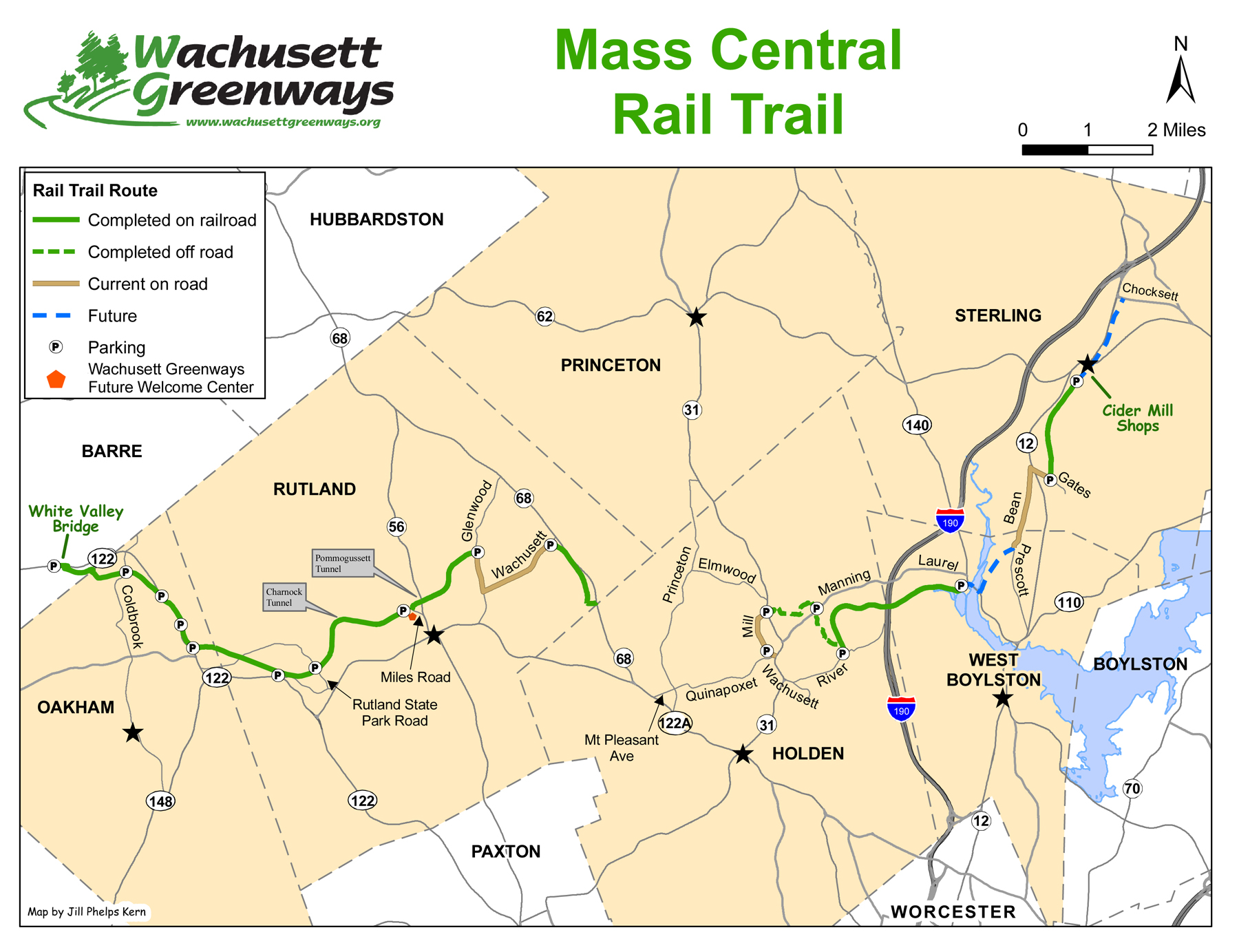
MCRT segment map by Wachusett Greenways.
Wachusett Greenways Region
Wachusett Greenways has been slowly building out its section of the MCRT whose total length is 30 miles. To date, 20 miles of stone-dust surface trail have been constructed and opened to the public, including a 100-foot bridge across the Quinopoxet River and two road underpass tunnels. While the remaining parts of the ROW are compromised in places, Wachusett Greenways continues to chip away at it a mile at a time.
The eastern section along the north side of the Wachusett Reservoir has not been completed. A major bridge project over one of the reservoir tributaries needs to be built before this section could be opened.
Clinton-Berlin
There is a gap between the Wachusetts Greenways section and the Berlin-to-Waltham DCR lease. In Clinton, the Central Massachusetts Railroad crossed the Nashua River below the Wachusett Reservoir dam on a high trestle and then passed through a 1,300-foot tunnel before continuing east toward Berlin. Unfortunately, in 1979, the high trestle was demolished, leaving only the concrete piers.
The town of Clinton has acquired the tunnel and the one-and-a-half miles of ROW east of the tunnel and intends to develop it into a shared-use path and part of the MCRT. Massachusetts Representative Jake Auchincloss is attempting to get funding in the upcoming infrastructure bill to recreate the high trestle across the Nashua River, an exciting possibility with spectacular views.
Berlin to Waltham
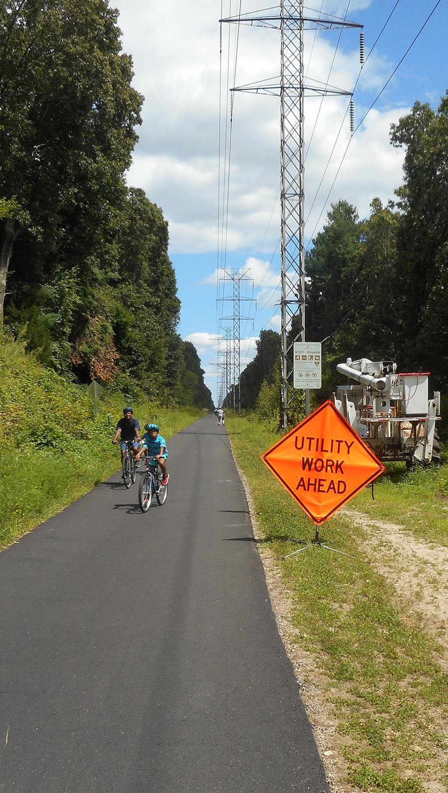
Summer 2020 MCRT construction in Wayland. Photo: John Dieckmann.
About five and a half miles of the MCRT in Weston and Wayland have been open to the public for more than a year. The electric utility Eversource built an access road for their transmission line which shares the ROW with the MCRT. The access road was paved with funding provided by the DCR and doubles as the shared-use path.
To the west in Wayland, Sudbury, and Hudson, a similar arrangement with Eversource and DCR will result in nine miles of paved path. The plan is to place the transmission line in an underground concrete trench alongside an access road/shared-use path. The town of Sudbury and a local environmental group, Protect Sudbury, are seeking to stop that construction by pursuing litigation. As of press time, litigation is still ongoing. If the suits are unsuccessful, construction of this section of the MCRT will probably take two years.
The ROW, which is leased by the DCR from the MBTA, continues into Berlin. Separate funding will be required to complete this short section.
In Waltham, the detailed design of the middle three-mile section is essentially complete. The city has stated it intends to fund path construction with Community Preservation Act funds. It is not clear when the city will issue a request for proposal for construction. The half-mile section connecting Waltham to Weston and the three-quarter mile section connecting the city to Belmont have not been designed.
Belmont Path Comments
The Belmont Community Path design team has responded to comments and questions submitted about the path last year. Read the entire 11-page document at bit.ly/BCF-Bike-Comments.
Issues addressed include
- Widening the Alexander Avenue culvert
- Providing privacy for abutters
- Stormwater flow and winter freezes
- Connections to Leonard Street
- Emergency vehicle access
… and many more
Belmont to North Point Park
The detailed design of Phase I of the Belmont Community Path segment of the MCRT has been delayed for the past several months pending an MBTA permit to allow borings for soil samples in the area around the proposed pedestrian underpass. The 25% design is otherwise ready for approval by MassDOT. After that approval, work on the 75%-level design could get underway, and an application for construction funding could be submitted.
The MCRT has been open for several years from Brighton Street in Belmont past Alewife Station to Davis Square and Lowell Street in Somerville. At Lowell Street, the MCRT joins the ROW of the Green Line Extension (GLX) ROW which runs to North Point Park. This MCRT section is expected to be completed this autumn. From North Point Park there is a connection over the Charles River lock to Boston.
Future Progress and Funding
According to Craig Della Penna, a long-time MCRT advocate, the MCRT is the signature shared-use trail project in the state, and Governor Charlie Baker wants to see significant progress. As a result, MCRT projects are likely to receive funding in a timely fashion. The proposed federal infrastructure bill also is likely to provide significant funding. The impetus for projects will still be local. Fortunately, there are active friends groups and town support for moving trail development forward all along the MCRT.
John Dieckmann is a director of the Belmont Citizens Forum.

Sorry, the comment form is closed at this time.