Drake Village, Arlington, and Lessons from Across the Northeast
By Jeffrey North & Vincent Stanton, Jr.
Development of the Belmont Community Path is proceeding in two phases. Phase I is close to the 100% design threshold. Planning for Phase 2, which will run from the Clark Street Bridge to the Waltham border, started in late 2022 when the town hired Pare Corporation and Toole Design.
The Pare team studied the route options during winter and spring 2023 and recommended a final route to the Community Path Project Committee (CPPC) in May 2023 (see “Belmont Community Path Route Take Shape, BCF Newsletter, September 2023.) The CPPC unanimously endorsed the recommended route, moving the decision to the Select Board.
A key element of the recommended route is a new pedestrian-bicycle bridge over the Fitchburg Line about 600 feet west of the Clark Street Bridge. One end of the proposed bridge would be located just east of 750 Pleasant Street, the other end behind the Belmont Housing Authority’s (BHA) headquarters building at 59 Pearson Road. Then the path would proceed west toward the Town Yard and Waverley Square, parallel to the Fitchburg Line, via a ramp along the back edge of the Belmont Village parking lot.
Because this new bridge and its associated ramp would partially be on (or extend over) land controlled by the BHA, which manages Belmont Village, it requires permission from the BHA. A BHA decision about the path has been delayed by ongoing planning, since 2020, to redevelop Belmont Village, which is 75 years old, and not well matched to the current needs of residents (e.g. no accessible units, no single units). The range of possible redevelopment options includes a multistory building at the back of the parking lot — very close to the proposed ramp.
What would it be like to have the path so close to Belmont Village? Are there any local precedents for paths adjacent to public housing? The answer is yes, there are many examples, including several in Arlington. In fact, the Arlington Housing Authority (AHA) on its website has a page titled “Our Properties” that provides a photo and a very brief description for all six AHA properties, five of which feature their proximity to a bicycle-pedestrian path:
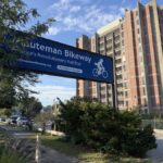
“Winslow Towers is an elderly/disabled high-rise development located steps to Arlington Center. It is located on the public transportation route and near the Minuteman Bikeway, local stores, shops, and restaurants.”
Sign for the Minuteman Bikeway next to Winslow Towers, an Arlington Housing Authority property. Photo: Vincent Stanton, Jr.
“Chestnut Manor is an elderly/disabled 100-unit high-rise development located within minutes of Arlington Center. It is located on the public transportation route and very near the Minuteman Bikeway, stores, shops, and restaurants.”
“Cusack Terrace is an elderly/disabled 67-unit high-rise development . . . located near Buzzell Field, the Donald Marquis Bikepath, and a short walk to Arlington Center.”
“The Drake Village Complex consists of two elderly/disabled developments . . . Both developments abut the Minuteman Bikeway, Hurd Field, and the Arlington Reservoir.”
“Mystic Gardens . . . five one-bedroom elderly/handicapped apartments and one two-bedroom affordable housing apartment . . . located near the Mystic River, Dugger Park, and the Alewife Greenway Bike Path.”
Clearly, the AHA views proximity to paths as an amenity.
Drake Village is a particularly interesting example. Built about a decade after Belmont Village, the older two-story buildings at Drake Village are also deteriorating, and no longer a good match for the Drake Village population. The AHA is planning to tear down those units and redevelop that part of the complex.
The 4.28-acre Drake Village Complex is surrounded by paths on all sides (see photo). To the south, the Minuteman Bikeway, the most widely used path in Massachusetts, runs within 57 feet of the two-story “cottages” and features a spur into the Drake Village parking lot. To the northeast is the Arlington Reservoir, which is circled by a popular walking path that also includes a spur into Drake Village. To the southwest is Hurd Field, a public park flanked by a walking path, and to the northwest is a smaller path that runs parallel to Sickle Brook, connecting the Minuteman Bikeway to the Arlington Reservoir path.
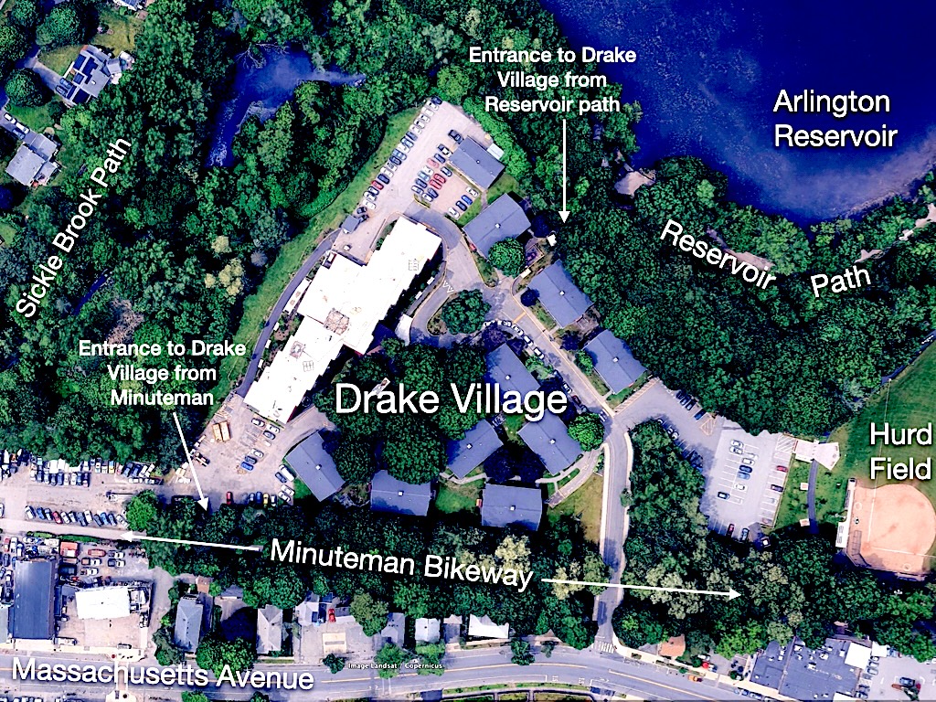
Map of the Drake Village site in Arlington. Graphic: Vincent Stanton, Jr.
The result: seniors and residents who are disabled can safely, and without a car, reach the 77 bus on Massachusetts Avenue, groceries, medical offices, and nature. Posted trail maps and guides show signed access points in Arlington, including parking off Drake Road, which is useful for visiting families, home health aides, and volunteer services that support residents.
Across the Northeast, other housing communities are discovering the same benefits.
Mobility, Health, and Safety
What makes this path so valuable? First, it promotes mobility and independence. A trail reduces the “first/last-mile” penalty that often isolates elders and low-income households from transit. The Minuteman runs 10 miles from Bedford Depot to Alewife Station and is maintained by the four host communities, reliability that matters when your trip is to a clinic or pharmacy.
Second, it enhances health and safety. Smooth grades and separation from traffic make it easier to meet daily step goals, take a neighborly stroll, or pedal to an appointment without braving Massachusetts Avenue. For older adults, that can mean more physical exercise and fewer falls.
Third, it creates community connection and stewardship. Trails bring foot traffic, eyes on the landscape, and volunteer attention, factors that correlate with better maintenance of the area and greater safety. While many studies focus on single-family home prices, the broader findings are consistent. Homes near rail trails show faster sales and strong demand, suggesting perceived neighborhood value from well-managed paths. Public housing communities can capture the same livability boost.

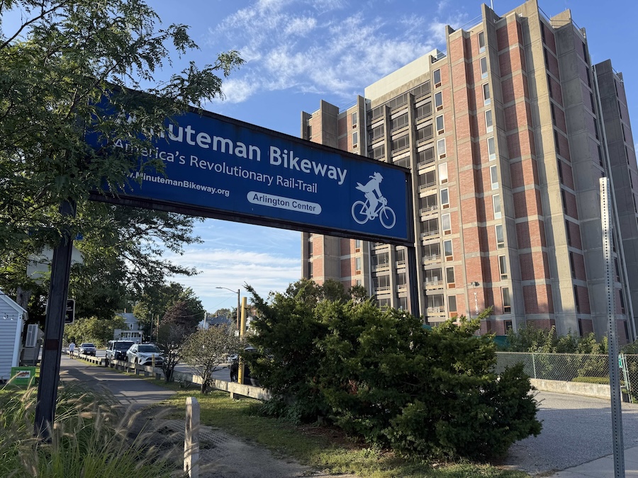
View of Drake Village from the Minuteman Bikeway. Photo: Vincent Stanton, Jr.
Other Local and Regional Examples
Arlington offers a second example: Mystic Gardens. There, the housing authority highlights proximity to the Alewife Greenway Path along the Mystic River, another off-street path linking residents to parks, bus routes, and commercial districts.
Across the river in Cambridge, the Rindge Towers/Fresh Pond Apartments (affordable high-rises on Rindge Avenue) sit beside the Alewife Linear Path, which connects directly to the Minuteman. Property information for the complex calls out “easy access to the Minuteman Bike Path,” underscoring how this network functions as a practical, everyday conduit for residents, especially those balancing work, childcare, and limited car access.
Beyond Massachusetts, other Northeast cities are learning similar lessons:
New Haven, Connecticut: The Farmington Canal Heritage Trail now runs through downtown neighborhoods with significant affordable housing, providing car-free access to jobs and services.
Providence, Rhode Island: The Woonasquatucket River Greenway lines a corridor of income-restricted and workforce housing, placing households directly on a safe bike and walking path to markets and schools. Some new net-zero affordable homes are being built right along the greenway, blending housing and sustainability in one stroke.
What Belmont Can Learn
Belmont’s future community path can apply these lessons:
- Design the “front door.” Wayfinding, lighting, and benches can make access real for seniors and people using assistive devices.
- Provide secure bike and mobility storage. E-bikes, trikes, and scooters expand who can use the path; safe storage expands participation.
- Close the last gaps. Safe crossings and winter maintenance are equity issues, not extras.
- Program the path. Walking clubs and volunteer “trail stewards” can help residents claim it as their space.
Drake Village shows how placing public housing beside a bikeway can extend health, independence, and dignity, one low-stress trip at a time. The Northeast’s growing trail network proves that when we connect front doors to paths, we connect people to opportunity.
Trails, Crime, and Property Values
Trails don’t raise crime. They increase value.
Dozens of studies across the United States and the Northeast show that well-designed rail trails, bike paths, and greenways do not increase crime in adjoining neighborhoods. In fact, many communities report the opposite: more “eyes on the trail” deter vandalism and improve neighborhood safety.
A 2019 review by the National Recreation and Park Association found no correlation between greenway construction and higher crime rates, while police departments often note fewer illegal dumping and trespass complaints once trails open.
The Rails-to-Trails Conservancy has documented similar outcomes in Massachusetts and Pennsylvania. Trail users and volunteers become a de facto neighborhood watch.
Proximity to trails and linear parks consistently boosts nearby property values.
Studies in eastern Massachusetts and upstate New York have shown homes within a quarter-mile of a major trail sell 3% to 11% faster or at higher prices than comparable homes farther away.
Realtors in Arlington, Lexington, and Somerville now advertise “steps to the Minuteman Bikeway” as a key amenity, proof that trails signal livability, convenience, and community vitality.
The takeaway: thoughtfully maintained, locally managed rail trails and greenways are not magnets for crime. They’re magnets for people who care about where they live.
Jeffrey North is the managing editor of the Belmont Citizens Forum Newsletter. Vincent Stanton, Jr., is a director of the Belmont Citizens Forum.

Sorry, the comment form is closed at this time.