Will Belmont Follow Suit?
By Vince Stanton Jr.
In September, the city of Waltham issued a request for proposal (RFP) for 100% design of a community path extending approximately three miles from the Waltham-Belmont border (about 1,000 feet west of Waverley Square) to the Weston border (about 1,500 feet west of Route 128, just south of Main Street). (“100% design” refers to a fully specified set of construction drawings.) Proposals were due on October 20. At a bidder’s conference on October 5, city officials expressed the hope that design work could be completed this winter, allowing construction to begin in 2017.
Design of the Waltham path would precisely define the western terminus of a future Belmont community path. More important, it would provide off-road connections to a variety of recreational, work, and cultural destinations in Waltham, including (from east to west) Beaver Brook Reservation, Waverley Oaks Office Park, the UMass Waltham Field Station and farm, Bentley University, the Lyman Estate, and Prospect Hill Park.
The Waltham path will be one segment of a longer route called the Wayside Trail, running . . . from Berlin, MA, to the Waltham-Belmont border.
 The map shows the course of the Wayside Trail (center). Solid lines indicate completed paths, dotted lines indicate high priority segments of the state’s long range Baystate Greenway plan, and ovals indicate high priority gaps in the path network. Note the oval at the Waltham/Belmont border. A more complete and inclusive trail map can be found here.
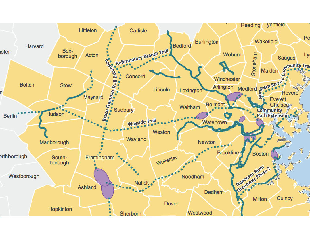
The Waltham path will be one segment of a longer route called the Wayside Trail, running about 23 miles from Berlin, MA, to the Waltham-Belmont border. In 2010, the Massachusetts Division of Conservation and Recreation (DCR) signed a 99-year lease with the MBTA securing a 19-foot-wide easement along the abandoned former Massachusetts Central Railroad (MCRR) right-of- way from Beaver Street in Waltham to Berlin, facilitating design and construction of the Wayside Trail.
The Wayside Trail . . . is part of a still grander plan to construct a 107-mile path, the Massachusetts Central Rail Trail . . . from Boston to Northampton, MA.
The Wayside Trail, in turn, is part of a still grander plan to construct a 107-mile path, the Massachusetts Central Rail Trail (MCRT), along the entire course of the former MCRR from Boston to Northampton, MA. About 28 miles of the MCRT have been completed, mostly in the central and western parts of the state. Design and construction of the MCRT, including the Wayside segment, has been identified as a priority in MassDOT and DCR planning documents.
In some respects, the news from Waltham is unsurprising.
• There is broad public support for a community path in Waltham.
• The route is set from Beaver Street to the Weston border along the DCR-leased right-of-way of the former MCRR.
• Mayor Jeanette McCarthy, who has been in office since 2004, has long supported a community path.
There is also support from the Waltham City Council, which will have to appropriate funds for path design and construction.
However, the city may have overlooked an important detail in its hurried issuance of the RFP, and the way Waltham’s leaders have chosen to implement and fund the design process is in some respects unconventional.
The first paragraph of the RFP is unambiguous in calling for design of a Belmont-to-Weston path: “The City of Waltham requests Design Services Proposals from experienced and qualified design and engineering firms to design and prepare construction documents for the Waltham component of the Wayside Trail which extends from the Weston line to the Watertown/Belmont line.” [Editor’s note: author’s emphasis added.]
This point was reaffirmed at the bidder’s conference, and it is significant because the Beaver Street-to-Waverley Square segment could otherwise be orphaned. Indeed, that segment has been ranked as a high-priority “gap” in the regional trail network by the Boston Regional Metropolitan Planning Organization (Boston MPO), the region’s federally designated transportation planning agency. (See map on page 5.)
However, the city may have overlooked an important detail in its hurried issuance of the RFP . . . because the Beaver Street to Waverly Square segment could otherwise be orphaned. Indeed, that segment has been ranked a high priority “gap” in the regional trail network . . .
However, between Beaver Street and the Belmont border (about 3,820 feet), neither Waltham nor DCR owns or controls a right of way (other than Waverley Oaks Road). The two key property owners in that gap are the MBTA, which owns parcels of variable width flanking the Fitchburg rail line, and Duffy Properties, which owns virtually all of the land north of the Fitchburg line to Waverley Oaks Road.
The Duffy property is bordered to the west by Beaver Street and to the east by Beaver Brook Reservation South, which includes Beaver Brook, a stream that marks the Belmont/Waltham border in that area. Certainly before path construction—and, one would think, before definitive path design—Waltham would have to negotiate a purchase, easement, or other agreement with one or both of those property owners. A 2012 Metropolitan Area Planning Council feasibility study discussed the route options in the Beaver Street-to-Belmont segment.
Some sections of the RFP suggest that at one time the scope of design may have been confined to the DCR-controlled Beaver Street-to-Weston segment. For example, a list of the street crossings requiring design does not include Beaver Street, and Exhibit C only shows the location of the path from Beaver Street to the Weston line. (Appendix D, on the other hand, is a map of Waltham annotated with a hand-drawn line showing the path hugging the north side of the Fitchburg line tracks from Beaver Street to the Belmont border.)
At the Weston end, the path will apparently follow the DCR-leased MCRR right of way, crossing Route 128 on the former MCRR railroad bridge just south of the Main Street (Route 117) vehicular bridge.
However, an alternative route has been proposed by 1265 Main, LLC, the developer of the former Polaroid site at the corner of Main Street and Route 128 (home to a recently opened Market Basket).
. . . an alternative route has been proposed by 1265 Main, LLC, the developer of the former Polaroid site.
The developer wants to construct new access ramps connecting his property to Route 128. That plan would apparently require demolition of the old railroad bridge and widening of the Main Street bridge from four lanes to seven, plus dedicated pedestrian and bicycle lanes. 1265 Main, LLC, has already constructed a segment of the Waltham path that traverses their property, just north of, and parallel to, Main Street.
At the bidder’s conference on October 5, city officials made it clear that the design and construction of the path would be funded by Waltham, mostly via funds yet to be appropriated by the City Council. A 2013 DCR slide presentation estimated the cost of design and construction at $5,371,000, not including rehabilitation of three historic truss bridges, estimated to cost an additional $1.2–$2 million for a total of $6.6–$7.4 million.
Self-funding would allow the city to control the design and construction process, but differs from the approach of other nearby communities that have sought federal and state funding for path design and construction.
The Boston MPO allocates federal Transportation Improvement Program (TIP) dollars, plus state matching funds, for a variety of infrastructure projects, including path design and construction, in 101 cities and towns roughly within Route 495. The Boston MPO expects to program $2.85 billion in federal highway funds during the next 25 years.
. . . the typical funding formula for path design or construction is 80% federal dollars, 10% state, and 10% local (municipal).
Path projects have to reach the 25% design stage and meet MassDOT design guidelines to be eligible for MPO funds, and it usually takes several years for a high quality project to get to the front of the Boston MPO funding queue. However, the typical funding formula, whether for path design or construction, is 80% federal dollars, 10% state, and 10% local (municipal).
Boston MPO funding for the Bruce Freeman Rail Trail, which connects Framingham and Lowell, illustrates why many communities find TIP money attractive, despite the slow process. In 2013, the Boston MPO voted to allocate $23 million to construct 7.5 miles of trail over three years, including a $6.3 million bridge over Route 2 in Concord, dedicated for trail use. Arlington recently received $1.6 million in TIP funds to design and construct an improved Massachusetts Avenue crossing for the Minuteman Bikeway. Closer to home, TIP money funded the $17.1 million Trapelo Road reconstruction project.
The Waltham announcement is exciting news for residents of both Waltham and Belmont. It will be interesting to watch the project progress over the coming months.
Vincent Stanton Jr. is a Belmont Citizens Forum board member, and a member of the Belmont Community Path Implementation Advisory Committee.
Links to cited and other relevant documents:
Waltham RFP for 100% design of Wayside Trail
More about the Boston MPO:
More about the TIP funding mechanism:
“Belmont/Waltham Community Trail Alignment Study” published by the Metropolitan Area Planning Council in 2012:
Video showing road reconfiguration at route 128 proposed by 1265 Main, LLC
https://www.youtube.com/watch?v=GVXbyWR1Gf0
Central Transportation Planning Staff study and ranking of gaps in the path network in the Boston Metropolitan Area:
http://www.ctps.org/Drupal/data/calendar/htmls/2014/MPO_0515_Bicycle_Network.html
Globe story on Boston MPO allocation of $23 M for Bruce Freeman Rail Trail:

Sorry, the comment form is closed at this time.