By David Chase
Belmont is an MBTA community. A new state law (Section 3A of MGL c. 40A) requires MBTA communities to have at least one zoning district of “reasonable size” and a minimum gross density of at least 15 units per acre within half a mile of commuter rail, subway, ferry, or bus station. The law specifies various formulas based on population and area that attempt to quantify “reasonable.” The zoning district must not have any restrictions that would make it unsuitable for families with children.
Belmont must have an Action Plan complete by January 31, 2023, and submit a District Compliance Application by December 31, 2024. An MBTA community action plan must provide information about current zoning, past planning for multifamily housing, and potential locations for a multifamily zoning district. The action plan also will require Belmont to establish a timeline for creating a compliant multifamily zoning district. Some parts of Belmont are already built this densely, but almost all preceded our current, less-dense zoning code.
This law was passed because Massachusetts, especially eastern Massachusetts, is in a housing crisis. Demand has grown far faster than supply, resulting in high and still-increasing rents and housing prices. High rents burden low- and middle-income families, and high prices cause would-be homeowners to pursue drive-till-you-qualify solutions to ever more distant exurbs, which are bad for the families, bad for traffic, and bad for Massachusetts. This law is supposed to encourage the creation of more housing units concentrated near transit access to reduce the traffic impact of the added housing.
Belmont’s case
MBTA communities comprise four categories: Rapid Transit, Commuter Rail, Adjacent Community, and Adjacent Small Town. With two commuter rail stops, Belmont falls into the Commuter Rail category.
The actual requirements are adjusted based on the amount of developable land in Belmont and the number of housing units in 2020. The main result is that Belmont’s transit-zoned areas must include at least 1,648 units (equal to 15% of Belmont’s current housing units, as the law specifies), have at least 15 units per acre, and contain at least 28 acres. Smaller areas require more units per acre, such that the total number of zoned units is at least 1,648.
Belmont may split the new zoning into two districts, where one must include at least 50% of the housing capacity and be located within a half mile of a commuter rail station. If Belmont seeks to minimize the increased density, the combination of required units and required density results in a size of 110 acres (110 acres x 15 units per acre = 1,650 units).
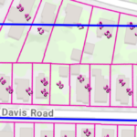
“Gross density” is computed by counting the permitted units on the existing lots within the district, and dividing that by the area of the entire zoning district including everything within it (for example, streets, parks, and churches). As an example, if the “district” is the lots along Beech Street between the businesses on Trapelo Road and Harris Street, then its area includes all the lots, all of the included sections of Beech Street, Wilson Avenue, Irving Street, Creeley Road, and half of Harris Street, or 5.3 acres, and by my count, 82 units, or a gross density of 15.5 units per acre.
However, almost none of these units could be built new on these lots with Belmont’s current General Residence (GR) zoning. The minimum GR lot size for a single-family home is 5,000 square feet, for a two-family, 7,000, and for a 3-family, 10,500. Most of these lots are under 5,000 square feet; most of these lots have two units, some three; and not a single lot is 7,000 square feet.
Belmont is filled with structures on lots that do not conform to their current zoning. Using Google Maps “Measure distance” combined with tax parcel data from MassMapper, shows that we already have blocks of some streets that are that dense—that is, all these structures existed before the current zoning rules and are now grandfathered, and they are densely developed. The east side of Davis Road from Trapelo to Irving (excluding the businesses on the end, as the current zoning already does), is dense.
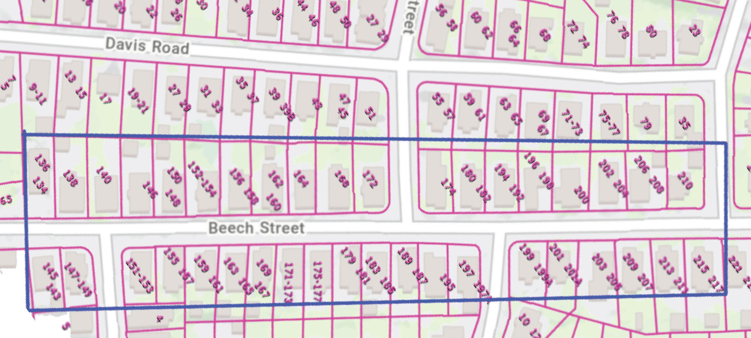
Belmont’s existing dense housing along Beech Street between Trapelo Road and Harris Street, totaling 14.4 units per acre. Outlined area as shown on MassMapper, maps.massgis.digital.mass.gov/MassMapper/MassMapper.html
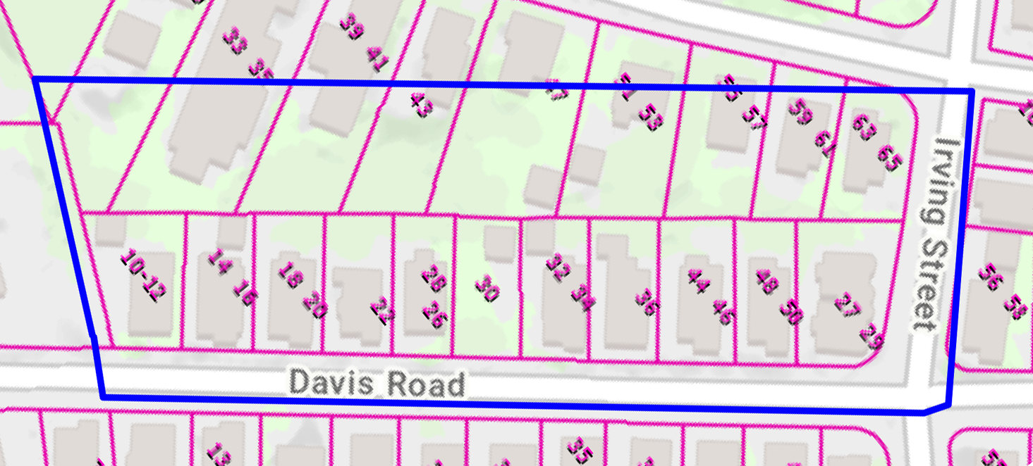
Dense building along Davis Road between Trapelo Road and Irving Street shown on Mass Mapper.
Beech Street, from Trapelo Road to Harris Street, includes 39 lots but has 2 more units than is needed to reach 15 units per acre.
These cases are cherry-picked and are some of the densest streets in Belmont. Still, they provide an example of the required density and suggest that if the new transit district is located around Waverley Station, it will minimize the number of new housing units added to Belmont. There are other considerations, but this is one plausible choice. If a transit district is located near Belmont Center, more units will be added, but again, the actual lots are much denser than the current zoning requires; instead of the required 9,000 square-foot lot, many are 6,000 square feet or smaller (though, unlike the Waverley area, few are two family).
This process of computing area and counting actual units is how a candidate district and set of zoning rules will be evaluated; given the lots in that district, list all the dimensions along which the town wishes to regulate development (for example, lot size and lot frontage), apply the rules to each lot to determine how many units the proposed regulations will allow on that lot, and consider the total across all lots; it should be 1,648, or larger. The actual mix of multifamily units can vary; if two-family structures are allowed on very small lots, then the threshold for three-family structures can be higher, and vice versa.
One side effect of this process is that under the new transit district zoning, many more (most?) of the existing housing will now comply with new frontage and area zoning requirements and may become easier to replace, renovate, or expand without seeking a special permit. A possible goal for the new zoning rules is to bring the largest possible number of existing structures into compliance while also achieving the required gross density.
To comply with the law, a transit zoning district must allow new construction of at least two-family homes on lots about like these, and on larger lots, three and perhaps four-family homes. State compliance staff will take GIS data for the chosen district(s) including lot-by-lot dimensional information, and count, for each lot, the number of units the new zoning will permit, then calculate the totals for the district.
The law’s effect
What this means in practice is that some areas of town will be chosen for denser zoning. The number of units that could be added, if it were all (re)built to the zoned capacity, is equal to 1,648 minus what is already built in that area. It doesn’t mean the town will build 1,648 new units, and of course, the units are not added until lots in the rezoned area are built up to their zoned capacity. If all 110 acres are like the Beech Street district, then there would be no units added. The main effect would be to make it more likely that existing construction conforms to Belmont’s zoning bylaws; this is true wherever we locate the district.
One big problem for Belmont in choosing this zoning district is that the town has sound reasons to prefer nonresidential development to residential development (see “Belmont is Sitting on a Fiscal Cliff,” BCF Newsletter, September/October 2022). Unfortunately, this law clearly requires zoning that should allow more residential development. Belmont has an incentive to choose the densest qualifying neighborhoods for the transit district so as to permit the smallest number of new units.
There are other concerns, of course. Our housing shortage makes rents and home purchases unaffordable for many. Increasing the number of T users would help the T’s fiscal situation and help justify continued service and perhaps justify improved service. If newcomers to the Boston area are instead forced to drive until they find affordable housing, there’s a good chance that they’ll end up adding to local traffic, either cutting through Belmont, or backing up nearby traffic in ways that will affect us.
Choosing districts will be politically tricky. Increasing density tends to be unpopular in Belmont, and housing development tends to be unpleasant for neighbors. The law intends to add housing, but the state’s lack of funding for education discourages it.
David Chase is a director of the Belmont Citizens Forum.

Sorry, the comment form is closed at this time.