By Meg Muckenhoupt
The Mugar wetlands are 17.7 acres of open land in East Arlington. Oaktree Development has proposed constructing a 207-unit apartment complex and six duplex townhouses on this site, to be renamed Thorndike Place. The Coalition to Save the Mugar Wetlands opposes building on the site, which is bordered by Route 2, Thorndike Field, and Dorothy, Edith, and Burch Streets.
The following interview with Clarissa Rowe, one of the founders of the Coalition to Save the Mugar Wetlands, was edited for length and clarity.
Why is the Mugar site important?
I think the reason Arlington and Belmont residents should care about this property is because it’s one of the last undeveloped sites in the area, and it serves as a buffer or sponge for all the water in our low-lying communities. We’re blessed to have wonderful water bodies in both towns, but also very high water tables, and when we get 100-year storms, which now happen more often than once every 100 years, we need somewhere to put that water.
Thanks to the overdevelopment of Cambridge up to both towns’ line, there’s no place for excess water to go. Because of new development in Belmont as well, East Arlington neighborhoods get flooded a lot more than they used to be. We need the Mugar site as a neighborhood sponge, and to use the land for education. We [the Coalition to Save the Mugar Wetlands] would like to develop the site as a place where school children can learn about how wetlands are important to the overall environment and are even more important in urban environments. We could show children what exactly is happening, and the benefits of an open space which collects stormwater and storm drainage from other sites, and make it a teaching opportunity.
What’s the current status of the Mugar site?
It’s an undeveloped site with some urban fill, probably from construction of the Red Line. There’s a lot of trash on it, and lots and lots of invasive vegetation like Phragmites reeds. There are also some wonderful old trees. We know these are wetlands because we see water on the site year-round. Water is especially prevalent in the springtime.
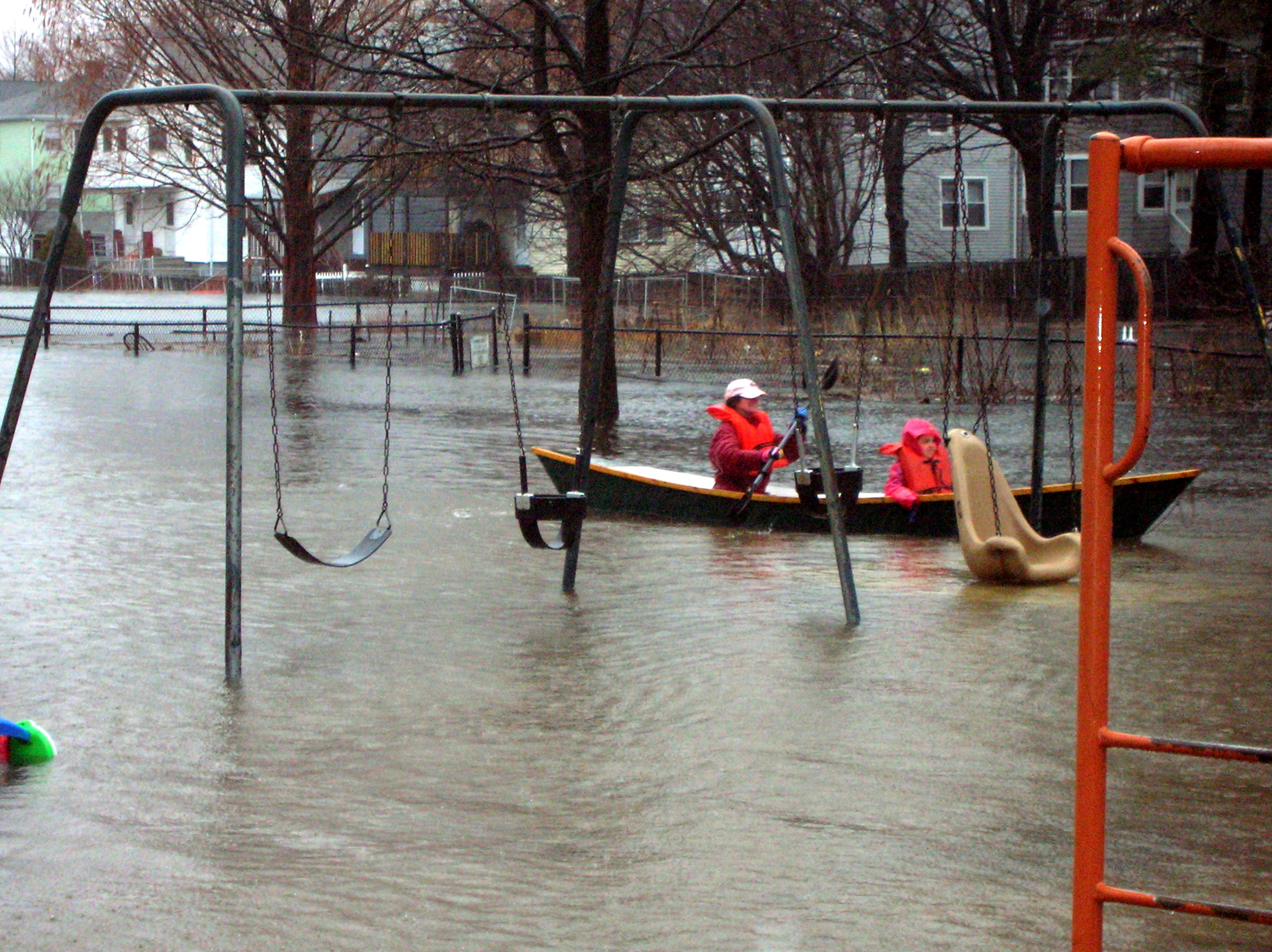
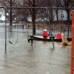
Arlington’s Magnolia Street Playground, 2010. Photo courtesy of Clarissa Rowe.
The Mugar land is next to one of Arlington’s most important sports complexes. It’s interesting to developers because the location is only a short walk to Alewife, the bike path, and the thickly developed East Arlington neighborhoods, consisting mostly of small two- to three- unit multifamily housing.
To developers, it’s an excellent place to get on and off Route 2 to enter Arlington, Belmont, or Cambridge. The problem is that those side roadways are packed. I live right off Lake Street in Arlington. During rush hour, going a quarter of a mile can take a half hour. The last time Oaktree Development presented to us, they said [Thorndike Place] wouldn’t do any harm to the traffic system. But that’s only because traffic is already rated an F there, at the Lake Street and Massachusetts Avenue intersection.
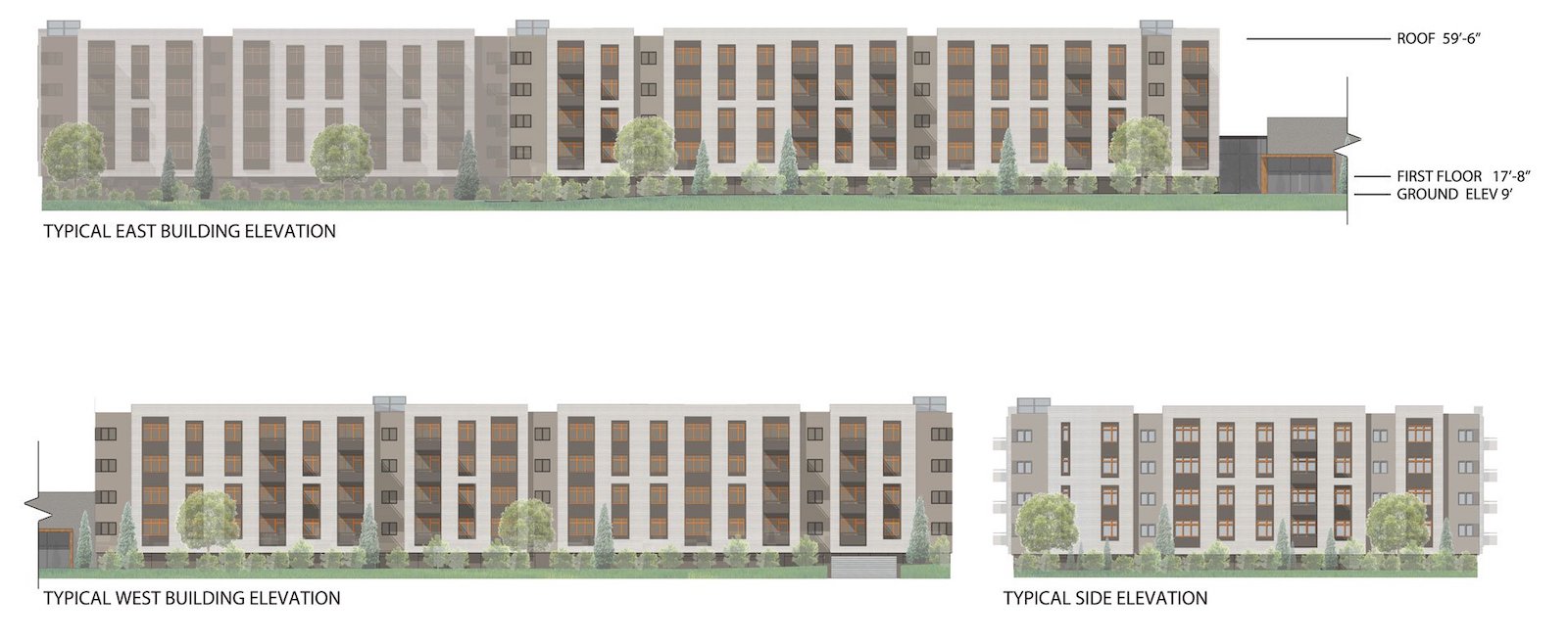
Side Elevations for Thorndike Place. Source: Greenstaxx.
What has the developer proposed?
The complex will have more than 200 housing units, and they were vague about the number of parking spaces. The last number I saw was 300. That would be a nightmare for the neighborhood. They’re thinking of building surface and “ground-level” parking under the building, like the developer did at the Faces site [now the Vox on 2 complex] across the way [Route 2].
It’s a 40R development, which means that it follows state rules for building affordable housing near mass transit. They’re saying it’s adjacent to the bike path and the T, and it’s positive because they’ll be including 55 affordable units. They said, “We don’t get many children coming to our apartments,” even though they know that the Arlington elementary schools are overcrowded. We’ve had to build four to five new classrooms for the Hardy School, and the Thompson School had to be expanded just a couple of years after it was rebuilt. The town can’t talk about the pressure of the schools as part of the 40B process—it’s off the table—but it’s a real issue for my town because East Arlington is a very desirable place to live, and we have overcrowding in the elementary schools.
Why is the coalition opposed to the development?
Flooding. Affordable housing is really important to us. Everywhere we can build affordable housing, we are, but we don’t believe that people in affordable housing should be living in a swamp. Traffic is obviously an important issue too.
We have a lot of affordable units coming online. We have two new developments in Arlington Heights, one in East Arlington about to be constructed. We’re building a lot of affordable housing. Arlington has little land, we just have a lot of water. We just don’t have any land to build on.
How is the developer dealing with wetlands on the Mugar site?
When the Mugar family came to Arlington’s Select Board in the 1990s, it was before FEMA redrew the boundaries of the floodplain in the mid-2000s. As of their last presentation, the developers failed to use updated FEMA maps in their work, and they obviously will have to. When I sat with them a few months ago, I said, “See this line? This is what you have to worry about.” I don’t know what agreement exists between the Mugar family and Oaktree Development – I think they have a lot of updating to do.
I’m very confident Arlington’s Zoning Board of Appeals and Conservation Commission will look carefully at what they’re presenting. A 40B developer has to provide $10K to the town to review its work, and the Arlington Land Trust has also offered to help raise additional funds if the town needs more money for expert reviews.
Arlington has had three overwhelming town meeting votes to deny developments on this site and other wetlands sites. It’s not just an East Arlington issue, it’s a townwide issue. People here get climate change, and how climate change is affecting our town.
I’ve worked with the developers on and off, as a Select Board member and as an Arlington Land Trust member. Their recent idea was to give the wetlands to the town for open space. It seems to me that they are handing the town the wetlands to manage. I asked, “Would an endowment come with that?” No, they just wanted a path to the T.
What is the current status of the development?
In the last go-round, the developers were using some survey and wetland delineation measurements from the 1990s. We [the Coalition] have suggested that information needs to be updated–both the survey and the wetland delineation–because of all the more recent construction nearby. They are going ahead with those surveys, and have asked the Zoning Board of Appeals for an extension until April to do the work. They are confident they can build, so they are updating the information.
What are the next steps for the developers?
The developers will be following the Chapter 40B process–going before the Zoning Board of Appeals and the Conservation Commission. We have to abide by the Commonwealth’s wetland regulations–the 40B process doesn’t allow local wetlands bylaws to be used. It’s supposed to create affordable housing, but what it doesn’t allow is local control. There are a lot of communities in Massachusetts that don’t want affordable housing, but that’s not true of Arlington. We do want affordable housing.
The Zoning Board of Appeals has to rule within 180 days, so we’re looking at a six-month process after submission. The Select Board is looking at different ways of dealing with the land.
What can Belmont learn from the Mugar site?
I think what makes Arlington and Belmont’s experiences different is that with the Belmont Uplands development, the town leaders were all in favor of it. In Arlington, our town officials and Town Meeting are completely agreed on not building on that site. It’s a very different political landscape. Belmont has a lot of undeveloped land, so leaders and residents can see this fight and learn from it. People worked really hard to modify the Uplands development, without success. We don’t know that we’re going to be any more successful, but we’re going to try.
If you live in an urban area, every piece of unbuilt land is important. The Uplands site came up for consideration before climate change was so much on people’s minds. We’re hoping that the growing awareness of climate change makes the difference.
Editor’s note: Though Belmont officials did favor development of a research and development complex on the Uplands site, they generally opposed housing and particularly the 40B Royal Belmont that was eventually constructed.
More Mugar Information
Oaktree Development has a page about the proposed Thorndike Place development on coUrbanize.com, which bills itself a “community engagement solution purpose-built for real estate developers and planners to connect with neighbors.”
The coUrbanize site states: “Thorndike Place proposes to construct a new 207-unit apartment building and 12 townhouse units, together with a preservation of approximately 11 acres of conserved land. The new development will provide excellent access to public transportation and employment opportunities in Arlington and beyond.”
To read more, see coUrbanize.com/projects/thorndike-place/information
For more information about the Coalition to Save the Mugar Wetlands, visit saveourwetlands.wordpress.com/
Oaktree Development’s plans for Thorndike Place are available at greenstaxx.com/portfolio/arlington/
Meg Muckenhoupt is editor of the Belmont Citizens Forum Newsletter.

Sorry, the comment form is closed at this time.