 By Jim Roth, Mary Trudeau, and Margaret Velie
On May 2, the Belmont Community Preservation Committee (CPC) approved the application by the Belmont Conservation Commission for $228,350 for the construction of the Intergenerational Walking Path and its entrances. Town Meeting approved the funds on May 4.
Golf is often described as “a good walk spoiled.” Those traversing the often muddy path around Clay Pit Pond in front of Belmont High School echo a similar sentiment.
Recreational walkers, joggers, dog walkers, cross-country skiers, and the high school crosscountry teams all use the well-worn earthen trail, even though it is often impassible due to poor drainage or flooding from Clay Pit Pond.
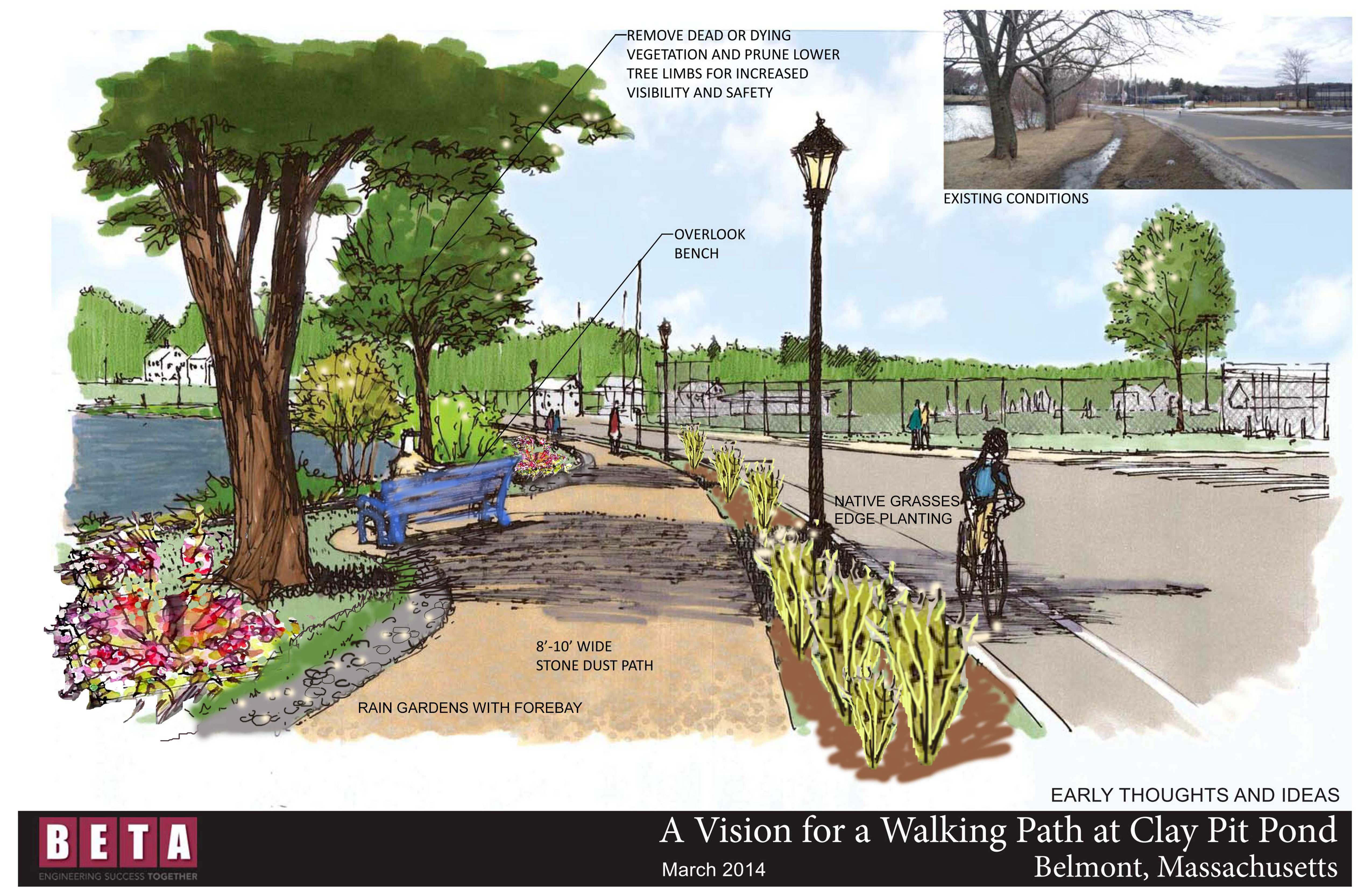
In 2013, the town Conservation Commission initiated a plan to change that experience with a proposal for the Intergenerational Walking Path at Clay Pit Pond. The commission applied for and received a $20,000 grant from the Belmont Community Preservation Act (BCPA) to hire landscape architect BETA Group to create a master plan to design a safe and fully handicapaccessible path system through Clay Pit Park.
The mission.
According to the commission, “The improved drainage and footing of the path is an environmentally sensitive improvement, designed to reduce sediment loading into the pond, improving the condition of the water body.” Loring Underwood, a Belmont resident and noted landscape architect of the early 20th century, designed the original park. The commission sought to restore Loring’s vision, enhance Belmont’s recreational opportunities, and vastly improve a deteriorating natural asset. The rehabilitation of the park, and development of the fully accessible path system, will provide a setting for both the veterans’ memorials and intergenerational educational opportunities. The myriad of associated projects have the potential to develop a uniquely Belmont landmark, in a visually important location.”
Citizen input.
BETA Group and the commission solicited input from various stakeholders about the values and important features associated with this park. In the spring of 2014, BETA held an on-site public design meeting to gather community preferences.
The community preferences included a formalized path, paved with permeable material and drainage; benches and seating along the path; an enhanced veterans memorial area including locations for new memorials, a gathering circle, and plaques; vegetation clusters to deter geese; kiosks; selective clearing to create access and views to the pond from Common Street; and an outdoor classroom area. The vision for the paths expressed by the community included: making them handicap accessible; permeable; runnable by high school teams; and in keeping with the historic, natural character of the park. Another goal was to open up views of the high school from Concord Avenue by clearing away much of the existing vegetation. BETA Group presented conceptual designs at a community meeting in the fall of 2014, and presented the draft master plan at a community meeting in June, 2015. The finished master plan design was delivered later that summer.
The master plan.
Clay Pit Pond occupies 13.5 acres, bounded by Belmont High School to the north, Hittinger Street to the east, and acres of parkland on the south and west. The final master plan breaks the project into more than a dozen discrete projects that can be undertaken separately. Some will require the town or outside contractors to construct, but others could be undertaken by volunteer groups, veterans, and scout troops.
Projects include: the public zone and school zone of the path; the veterans memorial area; the arboretum and Ruth Ippen Tree Walk; benches, bike racks, picnic tables, and trash cans; shore-line restoration; vista clearing; control of non-native and invasive vegetation; and replanting of historically appropriate vegetation within defined planting areas. For each project, BETA describes the community intent and existing conditions; provides a layout of the proposed design, including materials and specifications; and often provides a cost estimate.
Public Zone funded for $228,350.
The underpinning of the design is the Intergenerational Walking Path. In 2015, the commission submitted an application for $228,350 to the Belmont CPA to fund the construction of the entire Intergenerational Walking Path and its entrances.
One goal for the intergenerational walking path was to open up views of BHS from Concord Avenue by clearing away much of the existing vegetation. Another concern would be that building construction work on the BHS side of the pond could delay construction of the path, or damage it (if already constructed). Thus the scope of the path project was revised to include only the public zone of the path—approximately 2500 linear feet running along the south side of the pond between Hittinger Street and the western school driveway exit at Concord Avenue, as well as the eastern pedestrian entrance paths to the park.
The grant will allow for the construction of a well-drained permeable path, with full handicap accessibility along the outer perimeter of the pond between Hittinger Street and the school egress drive. While the path as currently proposed does not fully circumnavigate the pond, it is likely that the high school portion of the pathway will be constructed. The commission believes that the future work could be funded through a second CPA grant, or included in the budget for the high school.
History of the clay pit.
Although Clay Pit Park is not managed by the Belmont Conservation Commission, the commission remains actively involved with its protection and preservation. Under the Massachusetts Wetlands Protection Act, the commission is charged with regulating all activity that occurs within 100 feet of the pond. The commission has also sponsored and participated in volunteer cleanups, shoreline restoration (including a major restoration after the oil spill at Burbank), tree planting, and removal of invasive species. The commission has often heard from residents and neighbors about the worn and muddy condition of the path around the pond.
The parklands surrounding Clay Pit Pond represent the historical past of Belmont. A former brickyard of local renown, the town has owned the property since the late 1920s when the clay was exhausted at the site and the brickyard closed. The town realized early on the value of the land as an important parkland in Belmont.
Landscape architect Loring Underwood, of the Underwood and Caldwell firm, created a plan for the development of the (then) thirty-eight acre parcel. The pond of today was created when Underwood diverted Wellington Brook into the pit that remained from the extraction of the clay. By filling a portion of the pit and reshaping the water body, he resolved the changes in grade between the pond and Concord Avenue, creating the gently graded parkland that remains today. His original plan included a pathway around the perimeter of the pond, as well as a variety of gardens and architectural features.
A child of the Depression.
Much of the grading work on Underwood’s plan was done in the late 1930s as a Works Progress Administration project, but the park was not completed until the early 1960s. Until the late 1950s, portions of the site were used for dumping municipal debris. A local rumor persists that a steam shovel remains at the bottom of the pond.
The high school was built on the site in 1971.
The plan for the path follows the existing path and Underwood’s design except for areas near Hittinger and Underwood Streets that have required relocation due to drainage and flooding, and is routed slightly further from the pond, outside of the flood zone.
Path dimensions.
The proposed path is 6-feet to 8-feet wide and is composed of 3-inch deep aggregate over 6 inchesof coarser aggregate. To resolve issues with poor drainage, the path surface slopes slightly away from the pond, and portions of the path have subdrains installed along the edge of the path.
Possible future projects contemplated in the design plans include small rain gardens where puddles accumulate now.
The path will include a subtle tribute to the brick-making history of the property. BETA Design overlaid the original dimensions of the clay pit on the site, and at every location where the proposed walking path intersects the edge of the original clay pit, a band of brick pavers will be inlaid into the crushed-stone bedding of the path. This will create a visual reminder of the historic use of the site.
Jim Roth is chair, Belmont Conservation Commission, and Peg Velie is a member of the commission. Mary Trudeau is conservation agent for Belmont.

Sorry, the comment form is closed at this time.