EPA Pushes for Alewife Sewage Cleanup

 Environment, May/June 2023, Newsletter, Sewers, Stormwater, Water Quality  Comments Off on EPA Pushes for Alewife Sewage Cleanup
Apr 262023
 
EPA Pushes for Alewife Sewage Cleanup

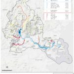
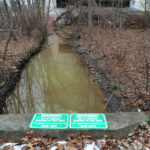
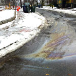
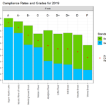
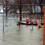
By Kristin Anderson and David White We are at an important point in the history of the Alewife Brook. The Massachusetts Water Resources Authority (MWRA) and the cities of Cambridge and Somerville are preparing a new long-term sewage control plan for the Alewife Brook/Upper Mystic River Watershed. Climate change, with its wetter rainy season, more intense storms, and sea level rise, is expected to result in more hazardous Alewife Brook sewage pollution and more flooding in the area. During some storms, the Alewife Brook floods into the houses, parks, and yards of area residents in environmental justice communities. Because of [READ MORE]

Share

Alewife Brook, Little Pond Get D Grades Again

 Environment, Newsletter, Sept/Oct 2022, Sewers, Water Quality  Comments Off on Alewife Brook, Little Pond Get D Grades Again
Sep 092022
 
Alewife Brook, Little Pond Get D Grades Again

By Meg Muckenhoupt In 1972, the Clean Water Act called for all waterways to be “fishable and swimmable” by 1983, and for all pollution discharges to end by 1985. That still hasn’t happened, as is shown by the new annual water quality report card issued by the Environmental Protection Agency (EPA) for the Mystic River in July. All of Belmont’s brooks received a D or D+ grade because they failed to meet state E. coli bacteria standards for boating in 45% to 55% of samples taken in 2021. Site 2021 2014 Grade Total Grade Total Alewife Brook D 47% D [READ MORE]

Share

Belmont’s Watersheds Cross Many Boundaries

 Environment, May/June 2022, Newsletter, Sewers, Water Quality  Comments Off on Belmont’s Watersheds Cross Many Boundaries
May 052022
 
Belmont’s Watersheds Cross Many Boundaries

By Anne-Marie Lambert Here in Belmont, we live on the edge of two large watersheds—the Mystic River watershed and the Charles River watershed. Understanding our role in these watersheds is more important than ever as storms in the Northeast grow more intense and more frequent, and as the rise in Atlantic Ocean sea levels starts to affect the underground water table.  The lack of alignment between our political maps and the topography of our watersheds can make it tricky to understand Belmont’s role. In the flat low-lying areas of town where there isn’t much gradient, waters flow in directions that [READ MORE]

Share
Mar 032022
 
Mystic Collaborative Plans For Climate Change

By Julie Wormser  Once upon a time, images of climate change featured skinny polar bears on melting ice floes, and hot, dusty desertscapes. Tragic for sure, but also very far away in time and space. Not any more. Last summer’s alarming weather—from 120 temperatures in the Pacific Northwest to record flooding rains here in the Northeast—has brought the immediate effects of climate change into sharper focus and more local concern. In Greater Boston, the most likely risks we need to prepare for are:  flooding from intense rainfall and coastal storms/sea level rise, hotter, drier summers, less predictable winter weather, and  [READ MORE]

Share
Jan 032022
 
Fifty Million Gallons of Sewage Released

Discharges to Alewife Brook Have Persisted for Two Decades By Kristin Anderson and David White Fifty million gallons of sewage-contaminated stormwater have been discharged into the Alewife Brook from the cities of Cambridge and Somerville in 2021, according to websites for those two cities and the Metropolitan Water Resources Authority (MWRA) for the Alewife/Upper Mystic Combined Sewer Overflow (CSO). There has been as much sewage-contaminated water discharged into the Alewife Brook in 2021 as there was in 1997 before the implementation of a $200 million plan to modernize the area’s antique combined sewer systems.  Pollution persists in the Alewife sub-watershed [READ MORE]

Share
Nov 012021
 
Stormwater Threatens Our Waterways

By Michelle Liebtreu and Daria Clark The Mystic River is cleaner today than it has ever been. The Clean Water Act has been a major environmental success story. But the work is not yet done. As the most urbanized watershed in New England, the Mystic River watershed is especially subject to stormwater pollution, one of the leading sources of pollution in our water today. Stormwater pollution, also known as stormwater runoff, occurs when rain falls over land—driveways, lawns, and streets—picking up fertilizer, dog waste, salt, leaves, and trash. That polluted water flows into the nearest storm drains and catch basins, [READ MORE]

Share

Belmont Waterways Get Failing Grades

 Newsletter, Sept/Oct 2020, Sewers, Stormwater, Water Quality  Comments Off on Belmont Waterways Get Failing Grades
Sep 032020
 
Belmont Waterways Get Failing Grades

By Meg Muckenhoupt The Mystic River’s most recent water quality report card, released on August 13, gives Winn’s Brook an F for 2019—and the Little River and Alewife Brook earned Ds. The US Environmental Protection Agency (EPA) creates the  annual report card in collaboration with the Mystic River Watershed Association. It grades segments of the Mystic River’s lakes, river, and streams on how frequently they meet bacterial standards for swimming and boating. The Upper Mystic Lake and the Chelsea River got an A grade; they met boating and swimming standards 90% or more of the time in 2019. Winn’s Brook [READ MORE]

Share

Arlington Group Opposes Mugar Site Plans

 March/April 2020, Newsletter, Open Space, Water Quality  Comments Off on Arlington Group Opposes Mugar Site Plans
Mar 022020
 
Arlington Group Opposes Mugar Site Plans

By Meg Muckenhoupt The Mugar wetlands are 17.7 acres of open land in East Arlington. Oaktree Development has proposed constructing a 207-unit apartment complex and six duplex townhouses on this site, to be renamed Thorndike Place. The Coalition to Save the Mugar Wetlands opposes building on the site, which is bordered by Route 2, Thorndike Field, and Dorothy, Edith, and Burch Streets. The following interview with Clarissa Rowe, one of the founders of the Coalition to Save the Mugar Wetlands, was edited for length and clarity. Why is the Mugar site important? I think the reason Arlington and Belmont residents [READ MORE]

Share
Jan 062020
 
Belmont Timeline

Belmont Timeline Featuring events significant to the Belmont’s history and Belmont Citizens Forum issues. 1654 The John Chenery house, 52 Washington Street, is built. The Chenery house is the oldest surviving house in Belmont. 1760 The Thomas Clark House is built on what is now Common Street. “Local tradition maintains that the Clark family witnessed the beginning of America’s War for Independence from the hill behind this house, seeing smoke and hearing the sounds of war breaking out on April 19, 1775.” —Joseph Cornish, BCF Newsletter,  January 2011. It was moved in 2012, and finally demolished in 2014. 1805 “Ice [READ MORE]

Share