Feasibility Study Plan would Renew Transportation Infrastructure and Create New Public Spaces
By Vincent Stanton, Jr.
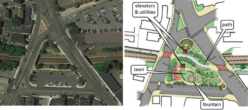
At left, an aerial view of Waverley Square, with Lexington Street on the left, Trapelo Road on the right, and Church Street at the bottom. At right, the feasibility study proposed to “box over” Waverley Station and move the parking lot onto Church Street, creating a 31,000-square-foot park traversed by the community path. (Pare Corp. K3 Landscape Architecture graphic)
A bicycle and pedestrian path stretching from the Charles River in East Cambridge to the town of Berlin, beyond Interstate 495, is in various states of design or construction. The path is complete from Brighton Street in Belmont to Lowell Street in Somerville (via Alewife station and Davis Square.) From the Belmont/Waltham border west to Route 128, a path is being designed. Construction is likely to start in early 2019.
That leaves a 2.1-mile gap in Belmont. Filling the gap is difficult because of Belmont’s dense settlement and hilly topography and because much of the former Central Massachusetts Railroad right-of-way through town was sold off. That right-of-way is the route for most of the Mass Central Rail Trail elsewhere.
In 2014 the Belmont Board of Selectmen appointed the Community Path Implementation Advisory Committee (CPIAC) to engage engineering and design consultants to study possible routes through Belmont. Last December, the selectmen accepted CPIAC’s recommendation to endorse the route proposed by Pare Corporation and K3 Landscape Architecture (“the Pare team”).1 The endorsement is an important step for the Belmont Community Path, but challenges remain. Funding for design and construction of the path must be secured, and the town must obtain necessary land parcels and easements.
The recommended route’s estimated cost is $27.9 million, assuming the most expensive option for each path segment (as mandated by CPIAC), and including a 40% contingency (30% is standard). The high contingency reflects the unusual level of interaction with the MBTA in the design and construction phases, because so much of the proposed path goes over, under, or parallel to the Fitchburg commuter rail line. The consultants also prepared a “lowest recommended” budget of $22.6 million by reducing retaining walls and landscaping.
Typically, path construction costs are paid from state and federal funds through the regional Transportation Improvement Program (TIP), which paid for the Fitchburg Cutoff path from Brighton Street to Alewife Station and for reconstruction of the Belmont Street/Trapelo Road corridor. Belmont’s responsibility is to provide the complete route, including environmental permitting, land acquisitions, and easements if necessary, and to pay for design. As a rule of thumb, path design costs about 10% of total project costs, which in this case would be $2.2 million to $2.8 million.
Upon completion of 25% design, which requires about half the design budget (5% of total costs), a project becomes eligible for review by the Boston Metropolitan Planning Organization, which allocates TIP funds. Although municipalities are usually responsible for all design costs, the Belmont path is not typical because of its extensive overlap with MBTA property, including the Fitchburg Line right-of-way (see below). Belmont should seek partial design funding from MassDOT.
The budget may seem rich for a pedestrian and bicycle path, but that description fails to capture the scope of the project proposed by the Pare team, which will transform all modes of transportation in Belmont, will fund vital infrastructure, and will create attractive new public spaces that Belmont could not otherwise even consider. Further, the cost per mile is in line with similar paths that parallel live rail lines, like the 1.9-mile path that will run beside the Green Line Extension from Lowell Street in Somerville to Lechmere in Cambridge.
This article is not intended to summarize the feasibility study (which is available on the town’s website) but rather to explain the proposed path’s benefits for Belmont—a subject largely beyond the scope of the study. In this issue of the newsletter, I will review three notable aspects of the project; in the next issue, I will cover three more. Sidebars provide additional context and history.
1. Bring Belmont commuter rail stations (almost) into ADA compliance
Older stations on the MBTA commuter rail lines are exempted from the requirement to comply with the Americans with Disabilities Act by a waiver granted by the Massachusetts Architectural Access Board (MAAB). However, station improvements above a certain percentage of value trigger expiration of the waiver. In 2012 the MBTA spent $353,000 to repair disintegrating platforms at Waverley station, well over the assessed station value of $44,000. The MAAB ordered the MBTA to make Waverley station ADA-compliant or to close it. (Any work at Belmont Center station would trigger a similar chain of events.)
In 2015 the MBTA proposed that Belmont Center and Waverley stations be replaced with a single station and parking garage on south Pleasant Street—a location distant from business or residential districts, with a garage that would draw additional traffic to clogged Pleasant Street. Faced with overwhelming community opposition, the MBTA sought and was eventually granted an MAAB waiver for Waverley station until June 2026. The MBTA argued that accessibility upgrades at other stations would benefit more customers. Without a plan for Waverley, the MAAB will likely compel the MBTA to close the station in eight years.
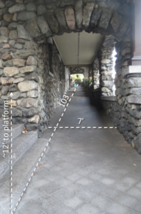
The 1907 ramp that wraps around the Lions Club. (Vincent Stanton, Jr. photo)
The Pare plan for Waverley Square, developed in consultation with the MBTA, includes elevators on each side of the tracks, connecting the path and surface parking to the train platforms approximately 21 feet below. Several adjacent property owners strongly support preserving Waverley station and making it fully accessible; a public-private partnership may enable better connections to neighboring businesses and residences on both sides of the station.
The Pare proposal does not, of course, provide the mini-high platforms that the MBTA uses to enable wheelchair boarding at most commuter rail stations and at many outlying Red and Green Line stations. However, the cost of building 45-foot-long mini-high platforms, together with ramps and stairs mandated by MAAB regulations, is likely to be low relative to full elevated platforms. For example, the MBTA is now replacing mini-high platforms at the Mansfield commuter rail station, plus rebuilding the train platforms, adding lighting, guard rails, bollards, signage, curb cuts, and parking lot improvements for better accessibility, all for $7.5 million.
At Belmont Center station, the Pare team proposes ADA-compliant connections from both the path and Concord Avenue to the edge of the north (outbound) train platform. Connection to the south (inbound) platform (not discussed in the Pare report) could be with an upgraded version of the existing system of wooden ramps over the tracks. Alternately, morning inbound trains could be re-routed to the north track, to minimize the need to use a cross-track ramp. (This system of routing trains through the most accessible side of a station is used elsewhere in the MBTA commuter rail system. The recently completed Fitchburg Line Improvement Project made switching tracks in Belmont possible by introducing a new crossover behind the high school.)
A third possibility, which would require the assent of the Belmont Lions Club, would be to re-open the 1907 ramp that wraps around the outside of the Lions club and connects the train platform to the Royal Road sidewalk. However, the ramp’s grade slightly exceeds the MAAB upper limit, and the ramp is broken by only one landing, while MAAB regulations specify landings at intervals of not more than 30 feet. Two new landings and a significant regrading of the ramp would be required.
As at Waverley station, separate funding for mini-high platforms at the Belmont Center station would be required. The curved tracks in that station present a challenge because mini-high platforms (which must extend 45 feet by MAAB regulations) have to be nearly flush with the edges of train cars to allow safe boarding. However, the tracks at the east end of the station, and extending over the granite bridge, are straight and should be compatible with 45-foot mini-high platforms.
With funding for the community path providing ADA-compliant connections to the Waverley Square and Belmont Center train platforms, the MBTA could build mini-high platforms at a small fraction of the cost proposed for complete ADA upgrades in 2015. This is Belmont’s best opportunity to preserve both commuter rail stations and to bring both into ADA compliance soon.
2. New connections to transit
New routes to mass transit provided by the community path should increase ridership on bus and train lines at Belmont Center and Waverley Square, as those destinations become easier and safer to reach for more residents. To maximize the value of transit connections, the town will need spurs off the main path.
The route recommended by the Pare team is compatible with four spurs (not in the budget; these will be a future phase of development), three of which would connect residents to the path and to important destinations in Belmont:
- A spur along Midland Street would connect the Waverley and Beech street neighborhoods to the path and provide access to the Beech Street Center and Town Field.
- A spur along Sherman Street to Alexander Avenue Extension would connect the Winn Brook neighborhood and school to the path and (via an Alexander Avenue underpass) to destinations on the south side of the tracks, including the high school, Underwood pool, playground, library, Powers Music School, and post office.
- A spur across the high school property from the new underpass to a proposed upgraded signalized crossing at Concord Avenue would connect the neighborhoods south of Concord Avenue (where the majority of Belmont lives) to the path.
(A fourth proposed spur would connect the path to the Beaver Brook Reservation, just east of the Waltham border.)
Regarding the future of Belmont’s commuter rail stations, state Senator Will Brownsberger, in a recent article on the MBTA’s long term planning process, expressed “hope that our existing rail commuter corridors can be used to provide more frequent subway-like service” in the future. As traffic in Belmont worsens, such service would be an attractive option for residents who commute to Boston or points west.
In addition to improved connections to transit within Belmont, the path will provide an off-road route to Alewife station and the Red Line. Estimated bicycling time from Waverley Square to Alewife station (for example, for a resident of Agassiz Avenue) would be about 15 to 18 minutes to cover three miles, which compares favorably to automotive transportation, especially at rush hour. Cost of parking: free.
The Belmont path, when connected to the Waltham path, will also provide improved connections for commuters, shoppers, or diners accessing businesses in the approximately one-million-square-foot Duffy Properties development between Waverley Oaks Road and the Fitchburg Line.
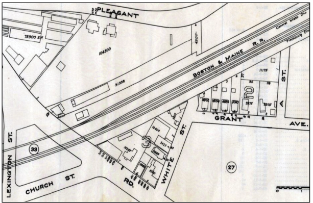
Waverley Square in 1931, with the Fitchburg and Central Mass railroad lines (both owned by Boston & Maine RR) traversing the square at grade. Note that the Fitchburg Line had three tracks and the CMRR had two tracks east of Trapelo Road. The Star Market area was occupied by greenhouses. (Belmont Town Assessor)
3. Restore Waverley Square
Waverley Square was actually a square (really more of a trapezoid) until 1952, when the present trench was excavated and the Trapelo Road and Lexington Street bridges were constructed over the subterranean station. Before 1952, the Fitchburg Line (opened in 1843) and the Central Massachusetts Railroad (opened in 1881) crossed the square at grade, each with its own station (see 1931 map). The Pare proposal is to erect a roof over Waverley Square station between Trapelo Road and Lexington Street and to create a park on the approximately 18,000 square feet of new space. That would reinvent the square and provide a focal point for future private redevelopment of properties flanking the square. The community path would traverse the park, which would help reinvigorate it as a public space.
Belmont has a thrifty culture, made necessary by our heavy dependence on residential taxes . . . The community path is a once-in-a-generation opportunity to refresh and extend town transportation infrastructure, while also transforming Waverley Square, all with (mostly) state and federal funding.
The Pare report also proposes moving the Waverley station parking lot south, onto Church Street, which would become one way (toward Lexington Street) with angled parking (see planners’ rendering on page 1). This reconfiguration would allow for “maintenance of the number of spaces currently in the Waverley station parking lot, but with closer proximity to the Waverley Square retailers,” according to the Pare study, and would add approximately 13,000 square feet to the park, for a total of about 31,000 square feet.
Just west of Waverley station, the path from Waltham, running along the embankment north of the Fitchburg Line, would split, with one arm ascending to cross Lexington Street into the new surface park and the other arm descending to connect to the station platform.
Without the community path, a new park in Waverley Square would not be imaginable. Whether this project element will be funded by the TIP remains to be seen, but in addition to being a boon to Waverley Square residents and landlords, the “box over” design also solves problems for the MBTA in terms of reduced station maintenance (no snow removal) and improved safety, and it fulfills MassDOT goals to increase multimodal transportation options.
Belmont has a thrifty culture, made necessary by our heavy dependence on residential taxes; approximately 95% of locally raised revenue (excluding state revenue-sharing for schools and roads, and a small amount of fee income) comes from homeowners. Belmontians historically are proud not only of the high performance of our schools and town services, but also of the efficient use of funds. The community path doesn’t fit easily into that framework. Rather it should be viewed as a once-in-a-generation opportunity to refresh and extend town transportation infrastructure, while also transforming Waverley Square, all with (mostly) state and federal funding.
Vincent Stanton, Jr. is a Belmont Citizens Forum board member. He served on the Community Path Advisory Committee (2012-2014) and is now a member of the Community Path Implementation Advisory Committee. However, the views in this article (and all sidebars) are entirely his own.
Footnote
1. The Pare Corporation and K3 Landscape Architecture were hired by the town in 2016 to identify feasible routes for a community path. To view the Belmont Community Path Feasibility Study and slide presentations the team made in public meetings, go to https://bit.ly/2ep3szk
Belmont’s Existing Community Path
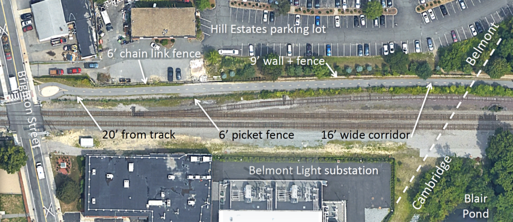
Belmont’s current bike path—the first 603 feet of the Fitchburg Cutoff path—is fenced in on both sides for its entire length, and lies 16 to 40 feet from the live rail. (Google Maps image)
Yes, Belmont already has a community path!
The first 603 feet of the Fitchburg Cutoff path, starting at Brighton Street, is located in Belmont. The remainder of the path (about 85%) is in Cambridge. The Fitchburg Cutoff path was an informal packed-earth shortcut from Belmont to Alewife station for decades before it was paved in 2011 and 2012. Its design and construction were entirely funded by the TIP program as part of a larger project connecting Alewife station to Davis Square.
This segment of the Fitchburg Cutoff path has been problem-free since the path opened.
The Belmont segment of the path is the least attractive part, bordered on both sides by walls or fences for its entire length (see above). For the first 1,150 feet, from Brighton Street and into Cambridge, the south edge of the path is between 20 and 40 feet from the Fitchburg Line tracks, except at the Brighton Street sidewalk where the separation narrows to 16 feet.
While neither the narrow, constricted path corridor nor the proximity to the Fitchburg Line tracks could be considered attractive design elements, the path has nevertheless become popular with pedestrians and cyclists, including young families and older citizens out for a walk.
Also worth noting is that this segment of the Fitchburg Cutoff path has been problem-free since the path opened. That should not be surprising; a 2013 study of 88 existing rails-with-trails in 33 states spanning 20 years showed that such paths are safe and increasingly popular.1
1 “America’s Rails-with-Trails Report,” published by the Rails to Trails Conservancy, is a study of 161 trails that run parallel to live rail lines. https://www.railstotrails.org/resource-library/resources/americas-rails-with-trails/
Funding the Belmont path: the “TIP” Funding process and beyond
The Transportation Improvement Program (TIP) is administered by MassDOT via the Boston Metropolitan Planning Organization (MPO); however, most of the money for TIP projects (80 or 90%, depending on the purpose) comes from the Federal Highway Administration or the Federal Transit Administration. Here’s how the Boston MPO website describes the TIP funding process:
Each year, approximately 150 transportation infrastructure projects, collectively costing more than one billion dollars, are submitted as candidates to receive funding through the Boston Region MPO’s rolling, five-year capital investment program, the Transportation Improvement Program (TIP). The types of projects that are eligible for TIP funding include intersection improvements, Complete Streets redesigns, bicycle and pedestrian connections, highway reconstruction, transit maintenance, and transit expansion. Typically, approximately $95 million is available in any given year for such projects . . . The vision established in the MPO’s Long-Range Transportation Plan, Charting Progress to 2040, guides the project selection process.
To be eligible for TIP funding, a path must have reached 25% design, though usually municipalities pay for full design. However, the Belmont Community Path will require closer cooperation with MBTA than typical paths in MassDOT District 4, which encompasses Belmont and 61 other communities mostly to the north and west, including Arlington, Everett, and Revere, but also small towns like Amesbury, Boxford, and Tyngsborough.
In Belmont, the path design and construction issues are much closer to those in MassDOT District 6, which includes Somerville and Cambridge, where a planned community path will run parallel to the new Green Line Extension (GLX) from Lowell Street in Somerville to Lechmere Square in Cambridge. That’s a closer analog to the Belmont path than the Massachusetts Central Rail Trail west of Belmont, which will occupy an abandoned right-of-way. Funding for design of the GLX path came from MassDOT and MBTA, not from Somerville or Cambridge (though when the project was in doubt, those cities did contribute significant resources for a redesign).
Virtually the entire Belmont path will either border or occupy MBTA land, including a tunnel, a bridge, and the covering over of Waverley station, all of which will help realize top MassDOT priorities relating to access, multi-modal transportation, and green initiatives.
The Belmont path has already been flagged as a high-priority segment of the regional path network by the Central Transportation Planning Staff of the Boston MPO and by the allied Metropolitan Area Planning Council (MAPC). An internal CTPS study1 ranked the Waltham to Waverley Square segment of trail second highest out of 234 “critical gaps” in the path network roughly inside route 495 (after a segment of the Somerville Community Path which has subsequently been constructed).
Since path design and construction will require extensive coordination with the MBTA and its contractors, there is a compelling case for MassDOT or MBTA to participate in the design and to absorb much of the cost.
1 “Bicycle Network Evaluation,” 2014 Boston MPO study prioritizing gaps in the community path network inside route 495 (author: Beth Isner) http://www.ctps.org/data/pdf/programs/livability/MPO_0515_Bicycle_Network.pdf
The Waltham to Waverley Square segment is covered in a more recent CTPS report entitled “Bicycle Network Gaps Feasibility Evaluations – Massachusetts Central Rail Trail” by Casey Claude, Boston Region MPO Staff
http://www.bostonmpo.org/data/pdf/studies/bikeped/Bike_Network_Gap_MCRT.pdf
Plus ça change . . .
In 1983 the Underpass Study Committee was created by Town Meeting to report on possible safe crossing routes at Alexander Avenue Extension, following the death of a high school student on the tracks in 1982. The committee deemed a tunnel too expensive and ended up recommending a pedestrian-bicycle path across the tracks at grade, with fencing to prevent crossing elsewhere. The MBTA was never consulted and the proposal went nowhere.
While differing in some details, all four studies mostly agree on the preferred route.
In 1994, the Belmont Bikeway Planning Committee (BBPC) was appointed by the selectmen and ultimately brought about the first Belmont-focused community path feasibility study. The design firm Wallace-Floyd Associates (WFA) was hired as consultant. The route recommended by WFA coincides with the Pare team’s preferred route in all but three locations:
- the idea of boxing over Waverley station was not considered by WFA;
- the Pare route avoids traversing Clark Lane by constructing a new pedestrian/bicycle bridge over the Fitchburg Line tracks behind the Belmont Housing Authority building at 59 Pearson Road, connecting to the south embankment of Pleasant Street;
- the Pare route connects the Clark Street bridge to Belmont Center station on the north side of the
tracks (vs. the south side in the
WFA route).
The latter two differences are related in part to new MBTA regulations regarding bridge clearance. When the current Clark Street footbridge was constructed in the mid-1990s, only 18-foot clearance was required. Now bridges need to clear tracks by 22.5 feet. Raising the Clark Street bridge 4.5 feet and connecting it to Clark Street would be expensive, thus helping justify the cost of a new bridge. Also, the northern route avoids the need to widen the underpass below Belmont Center Station, though it would still be an important link.
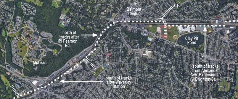
Routes proposed in various studies and reports since 1983 mostly align with the current recommended route, as marked above. Hatch lines indicate proposed spurs to help connect residents to the path. (Google Maps image)
The BBPC eventually dissolved and there was no town effort concerning a path from 2000 until 2011, when the Community Path Advisory Committee (CPAC, not to be confused with the current committee, CPIAC) was established by the selectmen. Members were appointed in May 2012, started meeting in August 2012, and delivered their final report in June 2014. The CPAC recommendations also line up closely with the Pare team’s recommended route, differing in two of the three segments noted above (no “box over’ at Waverley Square, and north and south routes were rated equal between Clark Street bridge and Belmont Center Station), and also in recommending a route along the north side of the tracks from Alexander Avenue Extension to Brighton Street (vs. the southerly route recommended in the Pare report). The northern route all the way to Brighton Street is the second ranked option in the Pare report—a fallback if the southern route from Alexander Avenue to Brighton Street cannot be implemented.
The Pare study is the fourth professional study of possible community path routes in Belmont and by far the most complete. The two studies not mentioned above were performed by state planning agencies: a 1997 study by the Central Transportation Planning Staff (CTPS) of the Boston Metropolitan Planning Organization covered a route along the former Massachusetts Central Railroad line from Berlin, MA, to Belmont, and a 2012 study by the Metropolitan Area Planning Council covered eastern Waltham and Belmont. All four studies are available on the Belmont town website (see links accompanying the online version of this article). While differing some details, all four studies mostly agree on the preferred route.
Look for “Belmont Community Path Update, Part Two” in the next issue of the BCF Newsletter.

Sorry, the comment form is closed at this time.